Category:Tour bleue (Charleroi)
Jump to navigation
Jump to search
| Object location | | View all coordinates using: OpenStreetMap |
|---|
|
The reproduction of this work is covered under the article XI.190 of the Code of Economic Law, which states that "Once a work has been lawfully published, its author may not prohibit: [...] 2/1°. reproduction and communication to the public of works of plastic, graphic or architectural art designed to be placed on a permanent basis in public places, provided that the reproduction or the communication of the work is as it is found there and that this reproduction or communication does not infringe upon the normal exploitation of the work and does not cause unreasonable harm to the legitimate interests of the author [...]."
See COM:CRT/Belgium#Freedom of panorama for more information.
|
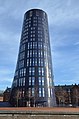
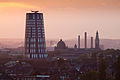
 Tour Bleue en août 2022. | |||||
| Upload media | |||||
| Instance of | |||||
|---|---|---|---|---|---|
| Location | Caserne Defeld, Charleroi, Arrondissement of Charleroi, Hainaut, Walloon Region, Belgium | ||||
| Street address |
| ||||
| Architect | |||||
| Has use | |||||
| Significant event |
| ||||
| Height |
| ||||
| Area |
| ||||
 | |||||
Media in category "Tour bleue (Charleroi)"
The following 26 files are in this category, out of 26 total.
-
 22891788764 Jpg (135021683).jpeg 2,048 × 1,365; 642 KB
-
 22892940753 Jpg (135021751).jpeg 2,048 × 1,365; 535 KB
-
 23224324620 Jpg (135021711).jpeg 2,048 × 1,365; 820 KB
-
 23493946686 Jpg (135021773).jpeg 2,048 × 1,365; 905 KB
-
 Charleroi - Tour bleue - 2015-01-31.jpg 2,969 × 4,485; 8.21 MB
-
 Charleroi - Tour bleue - 2019-12-28 - 01.jpg 3,143 × 4,745; 9.03 MB
-
 Charleroi - Tour bleue - 2019-12-28 - 02.jpg 4,597 × 3,046; 10.51 MB
-
 Charleroi - Tour bleue - 2019-12-28 - 03.jpg 3,153 × 4,760; 10.17 MB
-
 Charleroi - Tour bleue - 2019-12-28 - 04.jpg 2,692 × 4,065; 7.95 MB
-
 Charleroi - Tour bleue - 2019-12-28 - 05.jpg 2,782 × 4,201; 7.4 MB
-
 Charleroi - Tour bleue - 2019-12-28 - 06.jpg 3,731 × 2,472; 5.99 MB
-
 Charleroi - Tour bleue - 2019-12-28 - 07.jpg 4,403 × 2,917; 8.59 MB
-
 Charleroi - Tour bleue - 2019-12-28 - 08.jpg 3,264 × 4,928; 12.83 MB
-
 Charleroi - Tour Bleue - 2021-02-28 - 01.jpg 2,993 × 4,520; 13.23 MB
-
 Charleroi - Tour bleue - 2021-02-28 - 01.jpg 2,712 × 4,094; 8.92 MB
-
 Charleroi - Tour Bleue - 2021-02-28 - 02.jpg 4,566 × 3,026; 16.53 MB
-
 Charleroi - Tour bleue - 2021-02-28 - 02.jpg 2,985 × 4,507; 10.28 MB
-
 Charleroi - Tour Bleue - 2021-02-28 - 03.jpg 4,256 × 2,819; 10.9 MB
-
 Charleroi - Tour Bleue - 2021-02-28 - 04.jpg 2,531 × 3,824; 8.31 MB
-
 Charleroi - Tour bleue - 2022-03-22 - 01.jpg 2,512 × 3,792; 5.9 MB
-
 Charleroi - Tour Bleue - 2022-08-24 - 01.jpg 3,791 × 2,511; 6.23 MB
-
 Charleroi - Tour Bleue - état de la construction au 03-09-2013.jpg 2,304 × 3,072; 6.42 MB
-
 Charleroi - Tour Bleue - état de la construction au 05-05-2013.jpg 2,304 × 3,072; 5.2 MB
-
 Charleroi - Tour Bleue et résidence Plein Air - 2022-08-24 - 01.jpg 4,017 × 2,661; 7.23 MB
-
 Charleroi-ville-belgique-tour-bleue-paysafe.jpg 5,542 × 3,684; 2.18 MB
-
 Tour Bleue (Blue Tower).jpg 3,096 × 4,128; 3.15 MB
.jpeg)
.jpeg)
.jpeg)
.jpeg)


.jpg)