Category:Tong Po Chau Teng
Jump to navigation
Jump to search
| Object location | | View all coordinates using: OpenStreetMap |
|---|
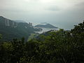
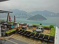
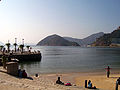
English: Tong Po Chau Teng is a 119m high hill located on Middle Island, Hong Kong. Its summit is the highest point of the island.
中文:熨波洲頂
Media in category "Tong Po Chau Teng"
The following 20 files are in this category, out of 20 total.
-
 Deep Water Bay 20201018.jpg 3,968 × 2,976; 5.52 MB
-
 Deep Water Bay Valley and Middle Island.jpg 3,264 × 2,448; 859 KB
-
 HK Ocean Park Cable Car Middle Island 9.JPG 1,600 × 1,200; 687 KB
-
-

-
 Hong Kong China Middle-Island-01.jpg 3,500 × 2,333; 4.11 MB
-
 Kwum Yam Shrine bird woman statue.jpg 2,592 × 1,944; 1.21 MB
-
 Laika ac Ocean Park (6374204501).jpg 3,868 × 2,909; 4.41 MB
-
 Middle Island & Chung Hom Kok viewed from Ocean Park.jpg 5,520 × 4,140; 9.74 MB
-
 Middle Island, Hong Kong 03.jpg 3,909 × 2,933; 3.06 MB
-
 Middle Island, Hong Kong 04.jpg 4,000 × 3,000; 3.62 MB
-
 Ocean Park 3.jpg 1,600 × 1,183; 307 KB
-
 Ocean Park 47, Hong Kong, Mar 06.JPG 1,200 × 1,600; 306 KB
-
 Ocean Park, Hong Kong - panoramio (1).jpg 2,560 × 1,920; 1.82 MB
-
 Ocean Park, Hong Kong - panoramio (5).jpg 2,560 × 1,920; 1.57 MB
-
 Repulse Bay 5.jpg 1,600 × 1,171; 307 KB
-
 Repulse Bay 7.jpg 1,600 × 1,200; 289 KB
-
 Repulse Bay from Ocean Park Cable Car (3030637265).jpg 600 × 800; 89 KB
-
 Repulsebay.jpg 3,264 × 2,448; 6.22 MB
-
 Shouson Hill viewed from Middle Gap.jpg 3,264 × 2,448; 1,023 KB


.jpg)


.jpg)
.jpg)


.jpg)

