Category:Thurlaston, Leicestershire
Jump to navigation
Jump to search
Cebuano: Thurlaston maoy parokya sa Hiniusang Gingharian. Ang Thurlaston nahimutang sa kondado sa Leicestershire ug apil sa nasod sa Inglatera, sa habagatang bahin sa nasod, ka molupyo. (→Thurlaston (parokya sa Hiniusang Gingharian, Leicestershire))
Cymraeg: Pentref a chymuned yn Lloegr ydy Thurlaston, Swydd Gaerlŷr; saif yn . (→Thurlaston, Swydd Gaerlŷr)
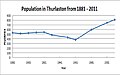
English: Thurlaston is a village and civil parish in Leicestershire, England. It is in the Blaby local government district, west of the City of Leicester. The 2001 census stated that the parish had a population of 745 (→Thurlaston, Leicestershire)
Polski: Thurlaston – wieś w Anglii, w hrabstwie Leicestershire, w dystrykcie Blaby. Leży 10 km na południowy zachód od miasta Leicester i 143 km na północny zachód od Londynu. (→Thurlaston (Leicestershire))
Svenska: Thurlaston är en parish i Storbritannien. Den ligger i grevskapet Leicestershire och riksdelen England, i den södra delen av landet, km nordväst om huvudstaden London. (→Thurlaston (parish i Storbritannien, Leicestershire))

village and civil parish in Leicestershire, England  | |||||
| Upload media | |||||
| Instance of | |||||
|---|---|---|---|---|---|
| Location | Blaby, Leicestershire, East Midlands, England | ||||
 | |||||
Subcategories
This category has the following 2 subcategories, out of 2 total.
N
- Normanton Turville (4 F)
T
Media in category "Thurlaston, Leicestershire"
The following 185 files are in this category, out of 185 total.
-

-
 A47 towards Leicester - geograph.org.uk - 5295376.jpg 640 × 480; 53 KB
-
 A47 trunk road turn right to Leicester - geograph.org.uk - 3141334.jpg 1,024 × 613; 208 KB
-
 All Saints Church - geograph.org.uk - 4878451.jpg 2,000 × 1,500; 187 KB
-
 All Saints Church, Thurlaston - geograph.org.uk - 5295202.jpg 640 × 480; 77 KB
-
 All Saints' church in Thurlaston - geograph.org.uk - 4355527.jpg 1,600 × 1,168; 366 KB
-
 All Saints, Thurlaston - geograph.org.uk - 5105619.jpg 1,000 × 649; 683 KB
-
 All Saints, Thurlaston - geograph.org.uk - 5105623.jpg 1,000 × 718; 652 KB
-
 All Saints, Thurlaston - geograph.org.uk - 5105624.jpg 1,000 × 713; 687 KB
-
 All Saints, Thurlaston - geograph.org.uk - 5105626.jpg 1,000 × 648; 683 KB
-
 Approach to Desford Crossroads - geograph.org.uk - 5726810.jpg 1,600 × 900; 499 KB
-
 Ash Spinney along Earl Shilton Road - geograph.org.uk - 6174415.jpg 800 × 517; 165 KB
-
 Bales next to the road to Hill Farm - geograph.org.uk - 4794713.jpg 800 × 548; 154 KB
-
 Bassett Farm driveway - geograph.org.uk - 183371.jpg 640 × 480; 97 KB
-
 Bend in Earl Shilton Road - geograph.org.uk - 5295206.jpg 640 × 480; 55 KB
-
 Bracknell Farm - geograph.org.uk - 4338556.jpg 1,600 × 1,083; 313 KB
-
 Church Street in Thurlaston - geograph.org.uk - 4355534.jpg 1,600 × 1,024; 444 KB
-
 Church Street, Thurlaston - geograph.org.uk - 169135.jpg 640 × 427; 116 KB
-
 Church Street, Thurlaston - geograph.org.uk - 3054779.jpg 856 × 1,280; 244 KB
-
 Clickers Way, Earl Shilton - geograph.org.uk - 2056173.jpg 640 × 480; 67 KB
-
 Clump Farm - geograph.org.uk - 1054903.jpg 640 × 349; 55 KB
-
 Croft Lane crosses the M69 - geograph.org.uk - 4588026.jpg 2,256 × 1,496; 910 KB
-
 Croft Road - geograph.org.uk - 5295183.jpg 640 × 480; 48 KB
-
 Croft Road enters Thurlaston - geograph.org.uk - 681309.jpg 640 × 420; 63 KB
-
 Croft Road near Thurlaston - geograph.org.uk - 5832245.jpg 1,600 × 900; 648 KB
-
 Crop field, Yennards Farm - geograph.org.uk - 5295182.jpg 640 × 480; 67 KB
-
 Depth gauge at Watery Lane ford - geograph.org.uk - 1136425.jpg 479 × 640; 177 KB
-
 Desford Road the B582 - geograph.org.uk - 3141209.jpg 1,024 × 768; 148 KB
-
 Differing crops - geograph.org.uk - 5224413.jpg 640 × 480; 61 KB
-
 Driveway to Hill Farm - geograph.org.uk - 678102.jpg 640 × 433; 72 KB
-
 Earl Shilton - geograph.org.uk - 60838.jpg 640 × 480; 133 KB
-
 Earl Shilton Road - geograph.org.uk - 4909163.jpg 2,000 × 1,500; 498 KB
-
 Earl Shilton Road - geograph.org.uk - 5295369.jpg 640 × 480; 57 KB
-
 Earl Shilton Road - geograph.org.uk - 5761792.jpg 1,600 × 900; 389 KB
-
 Earl Shilton Road from the junction with Thurlaston Lane - geograph.org.uk - 5230168.jpg 2,000 × 1,500; 458 KB
-
 Earl Shilton Road in Thurlaston - geograph.org.uk - 4794710.jpg 800 × 528; 177 KB
-

-
 Earl Shilton Road towards Thurlaston - geograph.org.uk - 678104.jpg 640 × 482; 115 KB
-
 Earl Shilton Road towards Thurlaston - geograph.org.uk - 681302.jpg 640 × 448; 99 KB
-
 Enderby Road - geograph.org.uk - 5441384.jpg 1,600 × 900; 229 KB
-
 Englands Farm, Croft Road, Thurlaston - geograph.org.uk - 169125.jpg 640 × 427; 101 KB
-
 Entering Thurlaston - geograph.org.uk - 5295186.jpg 640 × 480; 65 KB
-
 Entering Thurlaston - geograph.org.uk - 5831519.jpg 1,600 × 900; 432 KB
-
 Farm buildings off Croft Road - geograph.org.uk - 5295184.jpg 640 × 480; 61 KB
-
 Farm track near Hoefields Farm - geograph.org.uk - 4794630.jpg 800 × 571; 94 KB
-
 Farmhouse at New Hall Park Farm - geograph.org.uk - 4794690.jpg 800 × 620; 203 KB
-
 Farmland near Hoefields Farm - geograph.org.uk - 4794680.jpg 800 × 528; 126 KB
-
 Farmland near Normanton Turville - geograph.org.uk - 5295215.jpg 640 × 480; 72 KB
-
 Farmland near Thurlaston - geograph.org.uk - 266568.jpg 640 × 427; 102 KB
-
 Field to the south of Enderby Road - geograph.org.uk - 5044185.jpg 2,000 × 1,500; 493 KB
-
 Final Graph of Pop.jpg 864 × 540; 70 KB
-
 Fishing lake - geograph.org.uk - 5090031.jpg 2,000 × 1,500; 361 KB
-
 Footpath from Newhall Park Farm to Huncote Grange - geograph.org.uk - 4878596.jpg 2,000 × 1,500; 398 KB
-
 Footpath from Thurlaston to Enderby Road - geograph.org.uk - 5043364.jpg 2,000 × 1,500; 637 KB
-
 Footpath from Thurlaston to Leicester Forest West - geograph.org.uk - 5086791.jpg 2,000 × 1,500; 498 KB
-
 Footpath marker near Hoefields Farm - geograph.org.uk - 4794645.jpg 800 × 612; 127 KB
-
 Footpath to Thurlaston - geograph.org.uk - 5068122.jpg 2,000 × 1,500; 209 KB
-
 Ford on Watery Gate Lane, Earl Shilton - geograph.org.uk - 2888284.jpg 3,872 × 2,592; 2.32 MB
-
 Grassland west of Thurlaston - geograph.org.uk - 1054914.jpg 640 × 480; 87 KB
-

-
 Grazing and woodland, Thurlaston - geograph.org.uk - 5295205.jpg 640 × 480; 54 KB
-
 Grazing near Normanton House Farm - geograph.org.uk - 5295368.jpg 640 × 480; 67 KB
-
 Grazing north of Thurlaston Lane - geograph.org.uk - 5295372.jpg 640 × 480; 58 KB
-
 Grazing off Watery Gate Lane - geograph.org.uk - 5295180.jpg 640 × 480; 59 KB
-
 Grazing, Normanton Turville - geograph.org.uk - 5295208.jpg 640 × 480; 66 KB
-
 Hoefields Farm near Enderby - geograph.org.uk - 4794640.jpg 800 × 551; 131 KB
-
 Junction of Croft Road and Watery Gate Lane - geograph.org.uk - 5090104.jpg 2,000 × 1,500; 442 KB
-

-
 Looking south along the Earl Shilton Bypass - geograph.org.uk - 4338568.jpg 1,600 × 1,213; 304 KB
-

-
 M69 motorway from Croft Lane bridge.jpg 640 × 442; 55 KB
-
 M69 south of Thurlaston - geograph.org.uk - 4588019.jpg 2,256 × 1,496; 898 KB
-
 Main Street, Thurlaston - geograph.org.uk - 5295195.jpg 640 × 480; 61 KB
-
 Minor road to Thurlaston - geograph.org.uk - 5371477.jpg 2,322 × 4,128; 2.73 MB
-
 Muddy field near New Hall Park Farm - geograph.org.uk - 4794688.jpg 800 × 565; 124 KB
-
 Near to Normanton Wood - geograph.org.uk - 5761791.jpg 1,600 × 900; 349 KB
-
 New Hall Park Farm north of Thurlaston - geograph.org.uk - 4794698.jpg 800 × 567; 134 KB
-

-
 Normanton House Farm - geograph.org.uk - 5295371.jpg 640 × 480; 49 KB
-
 Normanton Wood - geograph.org.uk - 2087642.jpg 2,048 × 1,536; 1.25 MB
-
 North Lodge - geograph.org.uk - 3837273.jpg 2,097 × 1,395; 1.33 MB
-
 Occupation Statistics in Thurlaston from 2011 Census Data.jpg 882 × 614; 64 KB
-
 Poacher's - geograph.org.uk - 5105629.jpg 1,000 × 642; 618 KB
-
 Poacher's Bistro, Thurlaston - geograph.org.uk - 681307.jpg 640 × 380; 87 KB
-
 Poacher's Brasserie, Thurlaston - geograph.org.uk - 5295200.jpg 640 × 480; 56 KB
-
 Poachers, Thurlaston - geograph.org.uk - 1054933.jpg 640 × 480; 82 KB
-
 Pool at Normanton Park - geograph.org.uk - 4794722.jpg 800 × 580; 178 KB
-
 Population in Thurlaston from 1881 - 2011 Census Data.png 864 × 540; 15 KB
-
 Population in Thurlaston from 1881 - 2011.png 864 × 540; 16 KB
-
 Public footpath to Hoefields Farm - geograph.org.uk - 4794685.jpg 800 × 621; 194 KB
-
 Riverside Cottages - geograph.org.uk - 5295216.jpg 640 × 480; 56 KB
-
 Road leading to Normanton Turville - geograph.org.uk - 4794715.jpg 800 × 612; 124 KB
-
 Road to Hill Farm - geograph.org.uk - 5295207.jpg 640 × 480; 51 KB
-
 Rough pasture near Hoefields Farm - geograph.org.uk - 4794658.jpg 800 × 537; 119 KB
-
 Safety barrier along the Earl Shilton Bypass - geograph.org.uk - 4338553.jpg 1,600 × 1,101; 490 KB
-
 Sheep at Normanton Turville - geograph.org.uk - 4794719.jpg 800 × 495; 117 KB
-
 Sheep at Normanton Turville - geograph.org.uk - 4794721.jpg 800 × 538; 167 KB
-
 Sheep at Normanton Turville - geograph.org.uk - 5248167.jpg 800 × 607; 180 KB
-

-

-

-
 Small stream near Hoefields Farm - geograph.org.uk - 4794652.jpg 800 × 610; 156 KB
-
 Stream near Normanton Turville - geograph.org.uk - 5295213.jpg 640 × 480; 102 KB
-
 The A47 car boot sale site - geograph.org.uk - 3141225.jpg 1,024 × 768; 110 KB
-
 The A47 Hinckley Road - geograph.org.uk - 5812139.jpg 1,600 × 900; 397 KB
-
 The A47, Earl Shilton bypass, is named Clickers Way - geograph.org.uk - 5230162.jpg 2,000 × 1,500; 135 KB
-
 The A47, Hinckley Road, approaches Long Spinneys - geograph.org.uk - 5141612.jpg 2,000 × 1,500; 640 KB
-
 The Elephant and Castle, Thurlaston - geograph.org.uk - 1054925.jpg 640 × 480; 74 KB
-
 The Elephant ^ Castle - geograph.org.uk - 5068077.jpg 2,000 × 1,500; 263 KB
-

-
 The Elephant ^ Castle, Thurlaston - geograph.org.uk - 3054777.jpg 1,280 × 856; 258 KB
-

-
 The Gun Dog Bar ^ Restaurant in Thurlaston - geograph.org.uk - 4355549.jpg 1,600 × 1,122; 484 KB
-
 The Knoll along the A47 Leicester Road - geograph.org.uk - 3383704.jpg 3,412 × 2,414; 2.46 MB
-
 The Lower Pool at Normanton Park - geograph.org.uk - 4794723.jpg 800 × 624; 146 KB
-
 The M69 at Croft Lane bridge - geograph.org.uk - 3795889.jpg 1,200 × 900; 338 KB
-
 The M69 Motorway - geograph.org.uk - 5295173.jpg 640 × 480; 47 KB
-
 Thurlaston 1831 Census Industry Graph.jpg 768 × 614; 56 KB
-
 Thurlaston Chapel - geograph.org.uk - 1054928.jpg 640 × 480; 71 KB
-
 Thurlaston Chapel - geograph.org.uk - 3056029.jpg 856 × 1,280; 244 KB
-

-
 Thurlaston Garden Centre - geograph.org.uk - 6110301.jpg 1,600 × 1,014; 248 KB
-
 Thurlaston Lane overbridge, M69 - geograph.org.uk - 3589434.jpg 640 × 480; 55 KB
-
 Thurlaston Playing Field - geograph.org.uk - 1054936.jpg 640 × 480; 85 KB
-
 Thurlaston Pop Graph.jpg 1,008 × 630; 49 KB
-
 Thurlaston Saw Mill - geograph.org.uk - 169143.jpg 640 × 427; 126 KB
-
 Thurlaston-Church Street - geograph.org.uk - 6110306.jpg 1,600 × 1,200; 438 KB
-
 Total Industry Statistics from 1831 Census Data.jpg 864 × 540; 91 KB
-
 Track at the field boundary - geograph.org.uk - 5761789.jpg 1,600 × 900; 305 KB
-
 Track leading to New Hall Park Farm - geograph.org.uk - 4794703.jpg 800 × 538; 107 KB
-
 Track off the A47 - geograph.org.uk - 1036280.jpg 640 × 480; 107 KB
-

-
 Track to Normanton Park - geograph.org.uk - 5295211.jpg 640 × 480; 60 KB
-
 Traffic lights on the B582 Desford Road - geograph.org.uk - 4794617.jpg 800 × 547; 145 KB
-

-
 Unloved cottage - geograph.org.uk - 1054950.jpg 640 × 480; 89 KB
-
 Village Chapel - geograph.org.uk - 5371473.jpg 2,322 × 4,128; 2.04 MB
-
 Watery Gate Lane - geograph.org.uk - 5295179.jpg 640 × 480; 51 KB
-
 Watery Gate Lane fords Thurlaston Brook - geograph.org.uk - 5090074.jpg 2,000 × 1,500; 720 KB
-
 Watery Lane ford at Sunset - geograph.org.uk - 1136427.jpg 640 × 433; 177 KB
-
 Watery Lane ford at Sunset - geograph.org.uk - 1136428.jpg 474 × 640; 152 KB
-
 Welcome to Thurlaston - geograph.org.uk - 678106.jpg 640 × 502; 125 KB
-
 West Leicestershire view - geograph.org.uk - 1036283.jpg 640 × 480; 67 KB
-
 Woodland off Watery Gate Lane - geograph.org.uk - 5295176.jpg 640 × 480; 58 KB
-
 Yennards Cottages along Croft Road - geograph.org.uk - 4355499.jpg 1,600 × 1,073; 424 KB
-
 A47 Hinckley Road towards Leicester - geograph.org.uk - 699787.jpg 640 × 556; 112 KB
-
-
 Bend in the road - geograph.org.uk - 678100.jpg 640 × 445; 89 KB
-
 Countryside north of Thurlaston Lane - geograph.org.uk - 677938.jpg 640 × 390; 74 KB
-
 Countryside north of Thurlaston Lane - geograph.org.uk - 677953.jpg 640 × 480; 110 KB
-
 Countryside north of Watery Gate Lane - geograph.org.uk - 677835.jpg 640 × 420; 73 KB
-
 Croft Lane, Leicestershire - geograph.org.uk - 677784.jpg 640 × 394; 63 KB
-
 Earl Shilton Road - geograph.org.uk - 678058.jpg 640 × 407; 70 KB
-
 Earl Shilton Road near Thurlaston - geograph.org.uk - 681300.jpg 640 × 480; 96 KB
-
 Enderby Road towards Thurlaston - geograph.org.uk - 681313.jpg 640 × 421; 72 KB
-
 Enderby Road, east of Thurlaston - geograph.org.uk - 681310.jpg 640 × 448; 61 KB
-
 Enderby Road, Thurlaston - geograph.org.uk - 169138.jpg 640 × 427; 170 KB
-
 Farm road at Hoefields Farm - geograph.org.uk - 266563.jpg 640 × 427; 85 KB
-
 Farmland near Enderby - geograph.org.uk - 266569.jpg 640 × 427; 91 KB
-
 Farmland near Leicester Forest West - geograph.org.uk - 699764.jpg 640 × 420; 83 KB
-
 Farmland near Thurlaston, Leicestershire - geograph.org.uk - 169123.jpg 640 × 480; 157 KB
-
 Farmland near Thurlaston, Leicestershire - geograph.org.uk - 169147.jpg 640 × 427; 136 KB
-
 Farmland near Thurlaston, Leicestershire - geograph.org.uk - 169166.jpg 640 × 427; 115 KB
-
 Field at Hoefields Farm - geograph.org.uk - 266565.jpg 640 × 427; 98 KB
-

-
 Hill Farm, Thurlaston - geograph.org.uk - 362271.jpg 640 × 480; 71 KB
-
 Hurrying home before the rain^ - geograph.org.uk - 169148.jpg 640 × 427; 95 KB
-
 Normanton House Farm - geograph.org.uk - 678067.jpg 640 × 413; 75 KB
-
 Normanton Lodge - geograph.org.uk - 677828.jpg 640 × 478; 81 KB
-
 Normanton Lodge - geograph.org.uk - 677844.jpg 640 × 451; 83 KB
-
 Normanton Wood - geograph.org.uk - 362160.jpg 640 × 480; 71 KB
-
 Normanton Wood - geograph.org.uk - 678056.jpg 640 × 425; 59 KB
-
 North along Croft Road - geograph.org.uk - 677792.jpg 640 × 437; 71 KB
-
 North along Earl Shilton Road - geograph.org.uk - 678060.jpg 640 × 460; 74 KB
-
 North Lodge along the A47 Hinckley Road - geograph.org.uk - 699788.jpg 640 × 441; 102 KB
-
 Peckleton Lane junction - geograph.org.uk - 699760.jpg 640 × 427; 93 KB
-
 Potatoes for sale at Clump Farm - geograph.org.uk - 361235.jpg 640 × 480; 101 KB
-
 Public footpath to Peckleton - geograph.org.uk - 678095.jpg 548 × 640; 110 KB
-

-
 Small wood north of Watery Gate Lane - geograph.org.uk - 677822.jpg 640 × 466; 66 KB
-
 The B582 Desford Road - geograph.org.uk - 491641.jpg 640 × 480; 113 KB
-
 The B582 Desford Road - geograph.org.uk - 491643.jpg 640 × 517; 130 KB
-
 The Lodge in Spring - geograph.org.uk - 361337.jpg 640 × 480; 85 KB
-
 Westfield Farm 1868, 45 Desford Road - geograph.org.uk - 362317.jpg 640 × 480; 110 KB
-

_-_geograph.org.uk_-_1777899.jpg)


