Category:The Old House, Wallasey
Jump to navigation
Jump to search
| Object location | | View all coordinates using: OpenStreetMap |
|---|
grade II listed house in Wallasey, Wirral, Merseyside, UK   | |||||
| Upload media | |||||
| Instance of | |||||
|---|---|---|---|---|---|
| Location | Wirral, Merseyside, North West England, England | ||||
| Heritage designation |
| ||||
 | |||||
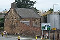
Stone house dated to 1697 and Grade II listed, on the corner of Limekiln Lane & Poulton Bridge Road.
Media in category "The Old House, Wallasey"
The following 11 files are in this category, out of 11 total.
-
 Datestone of The Old House, Wallasey.jpg 3,121 × 3,412; 10.64 MB
-
 Door of The Old House, Wallasey.jpg 3,346 × 5,003; 24.2 MB
-
 Plaque at The Old House, Wallasey.jpg 3,088 × 2,984; 7.94 MB
-
 The Old House, Poulton, Wallasey.jpg 4,320 × 3,240; 3.17 MB
-
 The Old House, Wallasey (rear view).jpg 5,152 × 3,864; 7.89 MB
-
 The Old House, Wallasey 1.jpg 4,168 × 3,544; 10.52 MB
-
 The Old House, Wallasey 2.jpg 4,496 × 3,152; 6.09 MB
-
 The Old House, Wallasey 2021-1.jpg 4,990 × 3,323; 17.81 MB
-
 The Old House, Wallasey 2021-2.jpg 4,891 × 3,427; 20.89 MB
-
 The Old House, Wallasey 2021-3.jpg 4,402 × 3,163; 17.67 MB
-
 The Old House, Wallasey 2021-4.jpg 4,139 × 3,268; 13.92 MB


.jpg)


