Category:The East Temple
Jump to navigation
Jump to search
mountain in Zion National Park in Washington County, Utah, United States  | |||||
| Upload media | |||||
| Instance of | |||||
|---|---|---|---|---|---|
| Located in protected area | |||||
| Location | Washington County, Utah | ||||
| Mountain range | |||||
| Topographic prominence |
| ||||
 | |||||
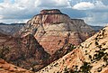
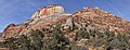
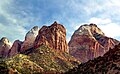
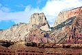
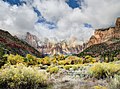
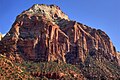
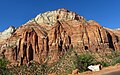
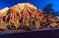
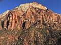
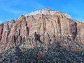
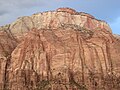
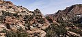
English: Media related to The East Temple, a 7,726-foot (2,355 m) Navajo Sandstone mountain in Zion National Park in Washington County, Utah, United States.
Media in category "The East Temple"
The following 31 files are in this category, out of 31 total.
-
 Above Zion-Mount Carmel Highway.JPG 8,057 × 2,342; 13.78 MB
-
 Double Rainbow (8119673976).jpg 4,000 × 2,696; 3.99 MB
-
 East aspect of The East Temple.jpg 3,058 × 1,886; 1.74 MB
-
 East Temple (5978844293).jpg 2,736 × 3,648; 5.75 MB
-
 East Temple (crop).jpg 1,814 × 1,222; 722 KB
-
 East Temple - Overlook Trail.jpg 6,629 × 2,551; 12.49 MB
-

-
 Looking Down on Zion Canyon.jpg 1,622 × 1,589; 813 KB
-
 Mount Spry and the East Temple.jpg 12,655 × 3,500; 13.42 MB
-
 Mt. Spry and East Temple.jpg 4,937 × 3,065; 11.07 MB
-

-

-
 Temple's Peak, Zion National Park - panoramio.jpg 5,184 × 3,456; 8.51 MB
-
 Temples and Towers of the Virgin (10681212885).jpg 5,971 × 4,416; 19.26 MB
-
 The East Temple from west.jpg 3,447 × 2,298; 1.42 MB
-
 The East Temple from Zion-Mount Carmel Highway.jpg 3,917 × 2,447; 3.13 MB
-

-
 The East Temple of Zion NP.jpg 8,254 × 5,301; 38.03 MB
-
 The East Temple of Zion Park.jpg 3,862 × 2,878; 3.73 MB
-
 The East Temple, from west. Zion Nation Park Utah.jpg 3,643 × 2,681; 2.3 MB
-
 The East Temple, Zion National Park, Oct 16.jpg 2,592 × 1,944; 2.29 MB
-
 The East Temple, Zion.jpg 2,816 × 2,112; 2.33 MB
-

-
 Twin Brothers from Deertrap.jpg 4,433 × 3,466; 3.53 MB
-
 View from the Overlook Trail.jpg 5,773 × 2,600; 6.62 MB
-
 Washington County, UT, USA - panoramio (33).jpg 3,264 × 2,448; 3.18 MB
-
 Zion National Park 1989 02.jpg 1,029 × 675; 854 KB
-
 Zion National Park lone tree 2005.jpeg 1,339 × 886; 694 KB
-
 Zion NP25.jpg 1,680 × 2,520; 3.39 MB
-
 Zion, Checkerboard Mesa, East Temple (3679383491).jpg 1,600 × 1,063; 561 KB
-
 Zion-Mount Carmel Highway, Zion National Park, Utah (1024920771).jpg 1,600 × 1,200; 323 KB
.jpg)

.jpg)
.jpg)


_over_Kayenta_Fm._(Upp._Triassic-Low._Jurassic),_Pine_Creek_Canyon,_Zion_National_Park,_sw_Utah_11.jpg)
,_Pine_Creek_Canyon,_Zion_National_Park,_sw_Utah_2.jpg)

.jpg)


.jpg)


.jpg)
.jpg)
Categories:
- Mountains of Utah
- Landforms of Washington County, Utah
- Mountains of Zion National Park
- Navajo Sandstone mountains
- 2350s mountains of the United States
- Locations along the Zion-Mount Carmel Highway in Washington County, Utah
- Locations along Utah State Route 9 in Washington County, Utah
- Locations along Utah State Route 15 (1912-1977) in Washington County, Utah
- Temple Cap Formation over Navajo Sandstone