Category:The Boundary pub
Jump to navigation
Jump to search
| Camera location | | View all coordinates using: OpenStreetMap |
|---|
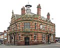
pub in Liverpool, Merseyside, UK  | |||||
| Upload media | |||||
| Instance of | |||||
|---|---|---|---|---|---|
| Location | Liverpool, Merseyside, North West England, England | ||||
| Heritage designation |
| ||||
 | |||||
Media in category "The Boundary pub"
The following 8 files are in this category, out of 8 total.
-
 Benchmark at The Boundary pub.jpg 4,554 × 3,408; 7.18 MB
-
 The Boundary Inn.jpg 2,048 × 1,536; 1.55 MB
-
 The Boundary Pub, Lodge Lane.jpg 1,984 × 1,488; 656 KB
-
 The Boundary pub, Smithdown Road, Liverpool (1).JPG 4,320 × 3,240; 2.75 MB
-
 The Boundary pub, Smithdown Road, Liverpool (2).JPG 4,320 × 3,240; 2.83 MB
-
 The Boundary public house - geograph.org.uk - 2075750.jpg 1,600 × 1,198; 334 KB
-
 The Boundary, Liverpool, 2016 1.jpg 4,480 × 3,608; 5.99 MB
-
 The Boundary, Liverpool, 2016 2.jpg 4,352 × 3,496; 5.62 MB


.JPG)
.JPG)

