Category:Tephra maps of Japan
Jump to navigation
Jump to search
日本語: 日本のテフラの地図
Media in category "Tephra maps of Japan"
The following 5 files are in this category, out of 5 total.
-
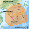 Aira AT tephra 29-26ka.svg 900 × 900; 1,004 KB
-
 Aso-4 tephra 90-85ka.svg 900 × 900; 992 KB
-
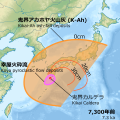 Kikai K-Ah tephra 7,3ka.svg 900 × 900; 986 KB
-
 Millenium-Eruption-map.jpg 600 × 400; 106 KB
-
 Volcanic-ash-downfall map of Mt.Fuji Hoei-eruption01.jpg 1,935 × 1,364; 1.54 MB


