Category:Tankinksweg 4
Jump to navigation
Jump to search
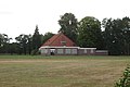
Nederlands: Openbare Basisschool Wiene
| Object location | | View all coordinates using: OpenStreetMap |
|---|
Media in category "Tankinksweg 4"
The following 7 files are in this category, out of 7 total.
-
 2019-08-05 Openbare Basisschool Wiene 2.jpg 4,000 × 2,248; 2.3 MB
-
 2019-08-05 Openbare Basisschool Wiene 3.jpg 4,000 × 2,248; 2.62 MB
-
 2019-08-05 Openbare Basisschool Wiene 4.jpg 4,000 × 2,248; 1.87 MB
-
 2019-08-05 Openbare Basisschool Wiene 5.jpg 4,000 × 2,248; 2.6 MB
-
 2019-08-05 Openbare Basisschool Wiene 6.jpg 4,000 × 2,248; 2.48 MB
-
 2019-08-05 Openbare Basisschool Wiene 7.jpg 4,000 × 2,248; 2.68 MB
-
 2019-08-05 Openbare Basisschool Wiene.jpg 4,000 × 2,664; 2.23 MB


