Category:Suwannee Springs Bridge
Jump to navigation
Jump to search
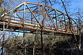
U.S. 129 abandonment alignment, 93rd Drive over Suwannee River in Suwannee Springs: Hamilton and Suwannee County, Florida. It is also known as the Ellaville Bridge and the Old U.S. 129 bridge.
| Object location | | View all coordinates using: OpenStreetMap |
|---|
 | |||||
| Upload media | |||||
| Instance of | |||||
|---|---|---|---|---|---|
| Location |
| ||||
| Crosses | |||||
 | |||||
Media in category "Suwannee Springs Bridge"
The following 17 files are in this category, out of 17 total.
-
 FL near old US 129 Suwannee River west01.jpg 4,288 × 3,216; 2.45 MB
-
 FL old US 129 Suwannee River bridge north01.jpg 4,288 × 3,216; 2.48 MB
-
 FL old US 129 Suwannee River bridge north02.jpg 4,288 × 3,216; 2.63 MB
-
 FL old US 129 Suwannee River bridge north03.jpg 4,288 × 3,216; 2.54 MB
-
 FL old US 129 Suwannee River bridge north04.jpg 4,288 × 3,216; 2.79 MB
-
 FL old US 129 Suwannee River bridge south01.jpg 4,288 × 3,216; 2.68 MB
-
 FL old US 129 Suwannee River bridge south02.jpg 4,288 × 3,216; 2.5 MB
-
 FL old US 129 Suwannee River bridge south03.jpg 4,288 × 3,216; 2.14 MB
-
 Suwannee Springs Bridge a.JPG 5,184 × 3,456; 9.82 MB
-
 Suwannee Springs Bridge b.JPG 5,184 × 3,456; 12.17 MB
-
 Suwannee Springs Bridge c.JPG 5,184 × 3,456; 12.38 MB
-
 Suwannee Springs Bridge d.JPG 5,184 × 3,456; 12.68 MB
-
 Suwannee Springs Bridge e.JPG 5,184 × 3,456; 11.34 MB
-
 Suwannee Springs Bridge f.JPG 5,184 × 3,456; 11.34 MB
-
 Suwannee Springs Bridge g.JPG 5,184 × 3,456; 10.45 MB
-
 Suwannee Springs Bridge h.JPG 5,184 × 3,456; 12.52 MB
-
 Suwannee Springs Bridge.jpg 3,872 × 2,592; 4.41 MB


