Category:Sundial at St Barnabas's Church, Bromborough
Jump to navigation
Jump to search
| Object location | | View all coordinates using: OpenStreetMap |
|---|
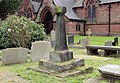
sundial in Bromborough, Merseyside, UK  | |||||
| Upload media | |||||
| Instance of | |||||
|---|---|---|---|---|---|
| Location | Wirral, Merseyside, North West England, England | ||||
| Heritage designation |
| ||||
| Inception |
| ||||
 | |||||
This is a category about listed building number 1343486. |
Media in category "Sundial at St Barnabas's Church, Bromborough"
The following 7 files are in this category, out of 7 total.
-
 Inscription 1, sundial at St Barnabas, Bromborough.jpg 5,184 × 3,456; 8.37 MB
-
 Inscription 2, sundial at St Barnabas, Bromborough.jpg 5,056 × 3,188; 7.99 MB
-
 Plate & gnomon, sundial at St Barnabas, Bromborough.jpg 3,004 × 2,528; 5.53 MB
-
 Sundial, St Barnabas, Bromborough 1.jpg 3,522 × 5,283; 12.46 MB
-
 Sundial, St Barnabas, Bromborough 2.jpg 3,554 × 5,331; 15.46 MB
-
 Sundial, St Barnabas, Bromborough 3.jpg 3,554 × 5,331; 15.62 MB
-
 Sundial, St Barnabas, Bromborough 4.jpg 4,811 × 3,318; 13.18 MB


