Category:Strauss-Lanner-Denkmal
Jump to navigation
Jump to search
| Object location | | View all coordinates using: OpenStreetMap |
|---|
 | |||||
| Upload media | |||||
| Instance of | |||||
|---|---|---|---|---|---|
| Commemorates | |||||
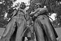
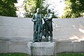
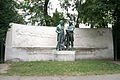
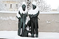
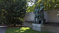
| Depicts | Johann Strauss I and Joseph Lanner | ||||
| Made from material | |||||
| Location | Rathauspark, Innere Stadt, Vienna, Austria | ||||
| Architectural style |
| ||||
| Creator | |||||
| Inception |
| ||||
| Date of official opening |
| ||||
 | |||||
 |
Media in category "Strauss-Lanner-Denkmal"
The following 14 files are in this category, out of 14 total.
-
 Lanner strauss.jpg 720 × 478; 118 KB
-
 Monumento Lanner strauss.JPG 2,816 × 1,880; 2.21 MB
-
 Strauss - Lanner Denkmal Nahaufnahme.jpg 2,000 × 3,008; 4.34 MB
-
 Strauss - Lanner.jpg 3,008 × 2,000; 4.25 MB
-
 Strauss-Lanner-DSC 2419.JPG 3,872 × 2,592; 3.65 MB
-
 Strauss-Lanner-DSC 2420.JPG 3,872 × 2,592; 3.57 MB
-
 Strauss-Lanner-IMG 5021.JPG 5,184 × 3,456; 7.78 MB
-
 Strauss-Lanner-IMG 5022.JPG 5,184 × 3,456; 8.75 MB
-
 Strauss-Lanner-IMG 5024.JPG 5,184 × 3,456; 8.17 MB
-
 Strauss-Lanner-IMG 5033.JPG 5,184 × 3,456; 8.93 MB
-
 Strauss-Lanner-IMG 8423.JPG 3,072 × 2,048; 2.77 MB
-
 Strauss-Lanner-IMG 8556.JPG 5,184 × 3,456; 5 MB
-
 Strauß Lanner Denkmal Rathauspark.jpg 5,629 × 3,753; 7.31 MB
-
 Wien 01 Rathauspark Strauss-Lanner a.jpg 3,000 × 1,687; 2.59 MB


