Category:Steinkreuz am Steinbrüchlein (D-5-64-000-2379)
Jump to navigation
Jump to search
Stonecross in Germany  | |||||
| Upload media | |||||
| Instance of | |||||
|---|---|---|---|---|---|
| Location | Nuremberg, Middle Franconia, Bavaria, Germany | ||||
| Street address |
| ||||
| Heritage designation | |||||
 | |||||
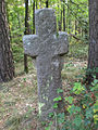
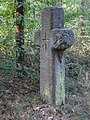
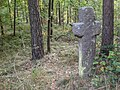
Deutsch: Steinkreuz, sog. Ullherkreuz oder Dilherrkreuz, Sandstein, wohl spätmittelalterlich; ca. 1000 m nördlich Ortsmitte Worzeldorf, westlich der Schwanstetter Straße.
Media in category "Steinkreuz am Steinbrüchlein (D-5-64-000-2379)"
The following 4 files are in this category, out of 4 total.
-
 D-5-64-000-2379 01.jpg 2,304 × 3,072; 2.45 MB
-
 D-5-64-000-2379 02.jpg 2,304 × 3,072; 2.31 MB
-
 D-5-64-000-2379 03.jpg 2,304 × 3,072; 2.47 MB
-
 D-5-64-000-2379 04.jpg 3,072 × 2,304; 2.56 MB


