Category:Station Engelbert
Jump to navigation
Jump to search
| Object location | | View all coordinates using: OpenStreetMap |
|---|
railway station in Groningen, the Netherlands  | |||||
| Upload media | |||||
| Instance of | |||||
|---|---|---|---|---|---|
| Location | Groningen, Netherlands | ||||
| Heritage designation | |||||
| Date of official opening |
| ||||
| Date of official closure |
| ||||
| Connecting line | |||||
 | |||||
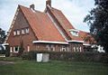
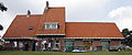
Nederlands: Het voormalige station van Engelbert, gem. Groningen, Woldjerspoorweg 40-42, gem.mon. 101668. Als station in gebruik van 1 juli 1929 tot 5 mei 1941.
|
This is a category about a municipal monument in Groningen with number 101668 |
Media in category "Station Engelbert"
The following 6 files are in this category, out of 6 total.
-
 Engelbert - Station (4 juli 2018).jpg 5,841 × 3,894; 7.24 MB
-
 Overzicht achtergevel aan de spoorzijde - Engelbert - 20365444 - RCE.jpg 1,183 × 1,200; 376 KB
-
 Overzicht voorgevel en linker zijgevel - Engelbert - 20365445 - RCE.jpg 1,181 × 1,200; 279 KB
-
 Station Engelbert.jpg 500 × 345; 25 KB
-
 Voormalig station Harkstede Groningen.JPG 4,681 × 1,949; 2.73 MB
-
 Voormalig station Harkstede.JPG 3,168 × 4,752; 5.89 MB
.jpg)


