Category:Stadtturm Olten
Jump to navigation
Jump to search
| Object location | | View all coordinates using: OpenStreetMap |
|---|
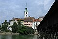
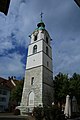
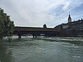
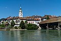
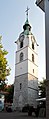
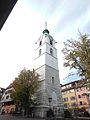
Deutsch: Stadtrundgang Objekt 25: Der Stadtturm wurde 1521 durch Konrad Gibelin von Solothurn als Glockenturm vor der 1422 abgebrannten und 1461 neu geweihten ehemaligen Stadtkirche errichtet. Er wurde von 1676 bis 1682 um ein Geschoss aufgestockt und barockisiert. Als die baufälligen Kirche 1844 abgebrochen werden musste, wurde der Stadtturm als Zeit- und Glockenturm stehen gelassen. Er wurde in den Jahren 1928, 1975 und 2006 renoviert.
clock tower in Olten in the canton of Solothurn, Switzerland  | |||||
| Upload media | |||||
| Instance of | |||||
|---|---|---|---|---|---|
| Part of | |||||
| Location | Olten, Olten District, Olten-Gösgen, Solothurn, Switzerland | ||||
| Street address |
| ||||
| Heritage designation | |||||
 | |||||
Subcategories
This category has only the following subcategory.
B
- Brunnen am Stadtturm (Olten) (6 F)
Media in category "Stadtturm Olten"
The following 54 files are in this category, out of 54 total.
-
 20170712 Olten 0842 (36764904342).jpg 5,760 × 3,840; 6.09 MB
-
 20170712 Olten 0865 (36935810815).jpg 3,840 × 5,760; 5.73 MB
-
 20170712 Olten 0866 (36764891002).jpg 3,840 × 5,760; 6.21 MB
-
 20180616 Olten 4333 (48392551702).jpg 7,952 × 5,304; 25.56 MB
-
 20180616 Olten 4334 (48392410581).jpg 7,952 × 5,304; 25.84 MB
-
 20180616 Olten 4338 (48392547652).jpg 7,952 × 5,304; 29.25 MB
-
 20180616 Olten 4342 (48392543972).jpg 7,952 × 5,304; 24.66 MB
-
 20180616 Olten 4343 (48392543122).jpg 7,952 × 5,304; 28.16 MB
-
 20180616 Olten 4349 (48392537557).jpg 5,304 × 7,952; 24.64 MB
-
 20180616 Olten 4350 (48392395871).jpg 7,952 × 5,304; 31.66 MB
-
 20180616 Olten 4352 (48392534657).jpg 5,304 × 7,952; 22.79 MB
-
 20180616 Olten 4357 (48392389496).jpg 5,304 × 7,952; 28.71 MB
-
 20180616 Olten 4358 (48392529052).jpg 5,304 × 7,952; 30.55 MB
-
 20180616 Olten 4359 (48392387081).jpg 5,304 × 7,952; 29.27 MB
-
 20180616 Olten 4361 (48392525722).jpg 5,304 × 7,952; 19.45 MB
-
 20180616 Olten 4362 (48392524812).jpg 5,304 × 7,952; 21.56 MB
-
 20180616 Olten 4452 (48392257766).jpg 7,952 × 5,304; 29.44 MB
-
 20180616 Olten 5401 (48392256091).jpg 3,264 × 2,448; 2.14 MB
-
 20180617 Olten 4510 (48400747017).jpg 7,952 × 5,304; 21.09 MB
-
 20180617 Olten 4511 (48400605346).jpg 7,952 × 5,304; 27.16 MB
-
 20180617 Olten 4512 (48400604116).jpg 7,952 × 5,304; 21.91 MB
-
 20180617 Olten 4513 (48400743887).jpg 7,952 × 5,304; 25.34 MB
-
 20180617 Olten 4514 (48400742907).jpg 7,952 × 5,304; 24.28 MB
-
 20180617 Olten 4515 (48400600981).jpg 7,952 × 5,304; 25.97 MB
-
 20180617 Olten 4516 (48400740612).jpg 7,952 × 5,304; 23.81 MB
-
 20180617 Olten 4517 (48400598786).jpg 7,952 × 5,304; 25.25 MB
-
 20180617 Olten 4518 (48400597681).jpg 7,952 × 5,304; 25.59 MB
-
 20180617 Olten 4519 (48400737622).jpg 7,952 × 5,304; 29.25 MB
-
 20180617 Olten 4520 (48400595561).jpg 7,952 × 5,304; 23.56 MB
-
 20180617 Olten 4522 (48400733937).jpg 7,952 × 5,304; 32.13 MB
-
 20180617 Olten 4524 (48400590886).jpg 7,952 × 5,304; 25.66 MB
-
 20180617 Olten 4529 (48400586161).jpg 7,952 × 5,304; 24.59 MB
-
 20180617 Olten 4530 (48400726237).jpg 5,304 × 7,952; 28.44 MB
-
 20180617 Olten 4531 (48400583996).jpg 7,952 × 5,304; 30.47 MB
-
 20180617 Olten 4532 (48400723832).jpg 7,952 × 5,304; 33.31 MB
-
 20180617 Olten 4533 (48400722517).jpg 7,952 × 5,304; 29.72 MB
-
 20180617 Olten 4534 (48400579696).jpg 7,952 × 5,304; 29.72 MB
-
 20180617 Olten 4538 (48400715742).jpg 7,952 × 5,304; 32.19 MB
-
 20180617 Olten 5328 (48400678497).jpg 7,952 × 5,304; 27.53 MB
-
 20180617 Olten 5331 (48400675042).jpg 7,952 × 5,304; 19.19 MB
-
 2020-Olten-Alstadt.jpg 1,920 × 1,280; 2.3 MB
-
 Alte Brücke OLTEN SO - panoramio.jpg 4,160 × 3,120; 4 MB
-
 Altstadtpartie an der Aare 20140514.jpg 2,560 × 1,440; 2.57 MB
-
 Olten Altstadt 1.JPG 3,444 × 2,586; 1.34 MB
-
 Olten old wooden bridge.jpg 4,032 × 3,024; 3.21 MB
-
 Olten Stadtturm Tuerband.jpg 3,698 × 2,465; 2.4 MB
-
 Olten Stadtturm.jpg 1,137 × 2,781; 868 KB
-
 Olten-stadtturm.jpg 2,448 × 3,264; 1.87 MB
-
 Picswiss SO-18-03.jpg 300 × 451; 49 KB
-
 Picswiss SO-18-08.jpg 294 × 450; 41 KB
-
 Picswiss SO-18-11.jpg 501 × 333; 63 KB
-
 Spring (5606254093).jpg 1,000 × 664; 320 KB
-
 Stadtturm Olten.jpg 3,456 × 4,608; 5.59 MB
-
 Turm - panoramio - TMbux (1).jpg 3,120 × 4,160; 4.91 MB
.jpg)
.jpg)
.jpg)
.jpg)
.jpg)
.jpg)
.jpg)
.jpg)
.jpg)
.jpg)
.jpg)
.jpg)
.jpg)
.jpg)
.jpg)
.jpg)
.jpg)
.jpg)
.jpg)
.jpg)
.jpg)
.jpg)
.jpg)
.jpg)
.jpg)
.jpg)
.jpg)
.jpg)
.jpg)
.jpg)
.jpg)
.jpg)
.jpg)
.jpg)
.jpg)
.jpg)
.jpg)
.jpg)
.jpg)
.jpg)


.jpg)

.jpg)