Category:Stadskantoor Etten-Leur
Jump to navigation
Jump to search
| Object location | | View all coordinates using: OpenStreetMap |
|---|
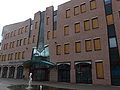
Nederlands: Afbeeldingen van het Stadskantoor Etten-Leur, Roosendaalseweg 4, 4875 AA Etten-Leur. Gelegen in het centrum van de gemeente Etten-Leur in de provincie Noord-Brabant in het zuiden van Nederland
Media in category "Stadskantoor Etten-Leur"
The following 4 files are in this category, out of 4 total.
-
 P1030488Stadskantoor Etten-Leur.JPG 3,264 × 2,448; 3.69 MB
-
 Stadskantoor Etten-Leur DSCF5178.jpg 1,536 × 2,048; 1.58 MB
-
 Stadskantoor Etten-Leur I01529.jpg 2,794 × 2,309; 1.5 MB
-
 Stadskantoor Etten-Leur P1490931.jpg 4,000 × 2,672; 5.86 MB


