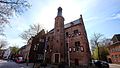
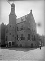
Category:Stadhuis ('s-Heerenberg)
Jump to navigation
Jump to search
| Object location | | View all coordinates using: OpenStreetMap |
|---|
former townhall in Gelderland, the Netherlands  | |||||
| Upload media | |||||
| Instance of | |||||
|---|---|---|---|---|---|
| Location |
| ||||
| Street address |
| ||||
| Located on street |
| ||||
| Heritage designation |
| ||||
 | |||||
|
This is a category about rijksmonument number 9274
|
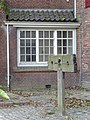
| Address |
|
Media in category "Stadhuis ('s-Heerenberg)"
The following 28 files are in this category, out of 28 total.
-
 2006-04 sheerenberg gemeentehuis.JPG 2,848 × 2,136; 1.44 MB
-
 7041 's-Heerenberg, Netherlands - panoramio (115).jpg 2,048 × 1,155; 541 KB
-
 7041 's-Heerenberg, Netherlands - panoramio (155).jpg 4,896 × 3,264; 2.83 MB
-
 7041 's-Heerenberg, Netherlands - panoramio (205).jpg 4,896 × 3,264; 1.9 MB
-
 Exterieur - 's-Heerenberg - 20105794 - RCE.jpg 869 × 1,027; 135 KB
-
 Exterieur - 's-Heerenberg - 20105795 - RCE.jpg 876 × 1,200; 166 KB
-
 Exterieur - 's-Heerenberg - 20105796 - RCE.jpg 871 × 1,200; 244 KB
-
 Exterieur - 's-Heerenberg - 20105797 - RCE.jpg 875 × 1,200; 172 KB
-
 Exterieur - 's-Heerenberg - 20105798 - RCE.jpg 891 × 1,200; 157 KB
-
 Exterieur vanuit het zuid-oosten - 's-Heerenberg - 20105799 - RCE.jpg 798 × 1,200; 201 KB
-
 Exterieur, reproductie naar oude foto - 's-Heerenberg - 20105792 - RCE.jpg 1,200 × 949; 224 KB
-
 Gevel - 's-Heerenberg - 20105791 - RCE.jpg 952 × 1,200; 209 KB
-
 Overzicht - 's-Heerenberg - 20105843 - RCE.jpg 948 × 1,200; 230 KB
-
 Overzicht voorgevel met traptoren - 's-Heerenberg - 20359548 - RCE.jpg 945 × 1,200; 231 KB
-
 Schandpaal stadhuis bergh.JPG 3,264 × 2,448; 2.57 MB
-
 Stadhuis 's-Heerenberg PM17-01.jpg 2,736 × 3,646; 2.78 MB
-
 Stadhuis 's-Heerenberg PM17-02.jpg 3,648 × 2,582; 2.44 MB
-
 Stadhuis 's-Heerenberg PM17-03.jpg 3,648 × 2,653; 3.69 MB
-
 Stadhuis 's-Heerenberg PM17-04.jpg 3,632 × 2,725; 3.74 MB
-
 Stadhuis 's-Heerenberg PM17-05.jpg 3,648 × 2,687; 3.32 MB
-
 Stadhuis 's-Heerenberg PM17-06.jpg 2,737 × 3,628; 3.36 MB
-
 Stadhuis 's-Heerenberg PM17-07.jpg 2,613 × 3,554; 3.2 MB
-
 Stadhuis 's-Heerenberg PM17-08.jpg 2,736 × 3,648; 3.51 MB
-
 Stadhuis 's-Heerenberg PM17-09.jpg 2,736 × 3,643; 3.24 MB
-
 Stadhuis 's-Heerenberg PM17-10.jpg 2,736 × 3,648; 3.55 MB
-
 Stadhuisbergh.jpg 2,048 × 1,536; 748 KB
-
 Voor de restauratie - 's-Heerenberg - 20105802 - RCE.jpg 763 × 886; 135 KB
-
 Bronzen trompet - 's-Heerenberg - 20105793 - RCE.jpg 1,200 × 958; 361 KB

.jpg)
.jpg)
.jpg)


