Category:St Patrick's Church, Earlestown
Jump to navigation
Jump to search
| Object location | | View all coordinates using: OpenStreetMap |
|---|
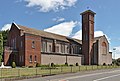
Roman Catholic church in Earlestown, St Helens, Merseyside, UK  | |||||
| Upload media | |||||
| Instance of | |||||
|---|---|---|---|---|---|
| Location | Earlestown, Newton-le-Willows, St Helens, Merseyside, North West England, England | ||||
| Inception |
| ||||
| Religion or worldview | |||||
 | |||||
Media in category "St Patrick's Church, Earlestown"
The following 9 files are in this category, out of 9 total.
-
 Doors of St Patrick's, Earlestown.jpg 4,731 × 3,134; 18.8 MB
-
 Porch of St Patrick's, Earlestown.jpg 4,502 × 2,821; 17.72 MB
-
 Statue of Jesus at St Patrick's, Earlestown.jpg 3,219 × 5,138; 20.7 MB
-
 St Patrick's Church, Earlestown 1.jpg 4,717 × 2,749; 18.28 MB
-
 St Patrick's Church, Earlestown 2.jpg 4,113 × 2,578; 13.33 MB
-
 St Patrick's Church, Earlestown 3.jpg 4,505 × 3,041; 18.17 MB
-
 St Patrick's Church, Earlestown 4.jpg 4,890 × 3,412; 20.51 MB
-

-
 Tower of St Patrick's Church, Earlestown.jpg 2,790 × 4,838; 19.36 MB


