Category:St Martin's church, St Martin's, Shropshire
Jump to navigation
Jump to search
| Object location | | View all coordinates using: OpenStreetMap |
|---|
church in Shropshire, UK  | |||||
| Upload media | |||||
| Instance of | |||||
|---|---|---|---|---|---|
| Location | St Martin's, Shropshire, West Midlands, England | ||||
| Diocese | |||||
| Heritage designation |
| ||||
| Inception |
| ||||
| Religion or worldview | |||||
 | |||||
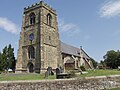
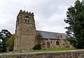
This is a category about listed building number 1367347. |
English: St Martin's parish church, St Martin's village, Shropshire: the west tower built in 1632
Media in category "St Martin's church, St Martin's, Shropshire"
The following 3 files are in this category, out of 3 total.
-
 St Martin's parish church at St Martin's, Shropshire.jpg 532 × 457; 171 KB
-
-
 St. Martins, St. Martins, Shropshire (geograph 4243963).jpg 1,600 × 1,118; 353 KB

.jpg)
Categories:
- 13th-century churches in Shropshire
- Anglican churches in Shropshire
- Churches in the Diocese of Lichfield
- Grade I listed churches in Shropshire
- Saint Martin churches in Shropshire
- St Martin's, Shropshire
- Hall churches in Shropshire
- Gothic churches in Shropshire
- Gothic Survival churches in Shropshire
- Perpendicular Gothic