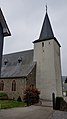
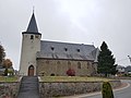
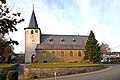
Category:St. Martin Kirche (Meyerode)
Jump to navigation
Jump to search
|
This is a category about a monument of the German-speaking Community of Belgium, number: 31008
|
| Object location | | View all coordinates using: OpenStreetMap |
|---|
kerkgebouw in Amel, Belgium _02.jpg) | |||||
| Upload media | |||||
| Instance of | |||||
|---|---|---|---|---|---|
| Dedicated to | |||||
| Location | Meyerode, Amel, Arrondissement of Verviers, Province of Liege, Walloon Region, Belgium | ||||
| Street address |
| ||||
| Diocese | |||||
| Heritage designation |
| ||||
 | |||||
Subcategories
This category has only the following subcategory.
I
Media in category "St. Martin Kirche (Meyerode)"
The following 20 files are in this category, out of 20 total.
-
 Amel-Meyerode, die Sankt Martin Kirche oeg31008 IMG 7584 2023-08-28 12.27.jpg 4,668 × 3,528; 7.47 MB
-
 Eglise Meyerode 4.jpg 640 × 480; 26 KB
-
 Meyerode Village.JPG 1,701 × 1,134; 575 KB
-
 Meyerode-Kirche St. Martin (1).jpg 2,268 × 4,032; 2.96 MB
-
 Meyerode-Kirche St. Martin (10).jpg 4,032 × 2,268; 1.9 MB
-
 Meyerode-Kirche St. Martin (11).jpg 4,032 × 2,268; 1.64 MB
-
 Meyerode-Kirche St. Martin (2).jpg 2,268 × 4,032; 2.21 MB
-
 Meyerode-Kirche St. Martin (3).jpg 2,268 × 4,032; 2.75 MB
-
 Meyerode-Kirche St. Martin (4).jpg 2,268 × 4,032; 2.79 MB
-
 Meyerode-Kirche St. Martin (5).jpg 4,032 × 2,268; 2.25 MB
-
 Meyerode-Kirche St. Martin (6).jpg 4,032 × 3,024; 3.42 MB
-
 Meyerode-Kirche St. Martin (7).jpg 4,032 × 3,024; 3.53 MB
-
 Meyerode-Kirche St. Martin (8).jpg 4,032 × 3,024; 3.07 MB
-
 Meyerode-Kirche St. Martin (9).jpg 4,032 × 2,268; 2.54 MB
-
 Pfarrkirche Meyerode.JPG 1,051 × 1,500; 1.04 MB
-
 St. Martin (Meyerode) 01.jpg 6,048 × 4,024; 2.62 MB
-
 St. Martin (Meyerode) 02.jpg 5,005 × 3,337; 1.94 MB
-
 St. Martin (Meyerode) 03.jpg 3,620 × 5,430; 4.36 MB
-
 St. Martin (Meyerode) 04.jpg 3,468 × 5,202; 3.51 MB
-
 St. Martin (Meyerode) 05.jpg 5,148 × 3,839; 4.28 MB


.jpg)
.jpg)
.jpg)
.jpg)
.jpg)
.jpg)
.jpg)
.jpg)
.jpg)
.jpg)
.jpg)

_01.jpg)
_03.jpg)
_04.jpg)
_05.jpg)
Categories:
- Churches in Belgium by name
- Meyerode
- Cultural heritage monuments in Amel
- Churches in Amel
- Saint Martin churches in Belgium
- 16th-century churches in Liège (province)
- 19th-century churches in Liège (province)
- Gothic churches in Liège (province)
- Gothic Revival churches in Liège (province)
- Hall churches in Liège (province)