Category:St. Maria Magdalena (Weingraben)
Jump to navigation
Jump to search
| Object location | | View all coordinates using: OpenStreetMap |
|---|
| This category shows the protected monument with the number 50274 in Austria. (Commons, de, Wikidata) |
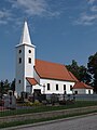
cemetery in Weingraben, Austria  | |||||
| Upload media | |||||
| Instance of | |||||
|---|---|---|---|---|---|
| Named after | |||||
| Location | Weingraben, Oberpullendorf District, Burgenland, Austria | ||||
| Street address |
| ||||
| Heritage designation | |||||
 | |||||
Media in category "St. Maria Magdalena (Weingraben)"
The following 6 files are in this category, out of 6 total.
-
 Kirche weingraben.JPG 2,736 × 3,648; 2.17 MB
-
 St. Maria Magdalena Weingraben 01.jpg 5,784 × 3,856; 8.17 MB
-
 St. Maria Magdalena Weingraben 02.jpg 5,294 × 3,530; 5.08 MB
-
 St. Maria Magdalena Weingraben 03.jpg 5,287 × 3,525; 5.8 MB
-
 Weingraben Pfarrkirche Innenansicht.jpg 4,592 × 3,056; 2.07 MB
-
 Weingraben Pfarrkirche.jpg 4,592 × 3,056; 2.41 MB


