Category:St. Gallus (Unterschwarzach)
Jump to navigation
Jump to search
| Object location | | View all coordinates using: OpenStreetMap |
|---|
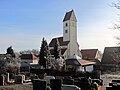
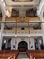
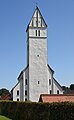
church building in Bad Wurzach, Tübingen Government Region, Bade-Württemberg, Germany -a.jpg) -i.jpg) | |||||
| Upload media | |||||
| Instance of | |||||
|---|---|---|---|---|---|
| Named after | |||||
| Location | Bad Wurzach, Landkreis Ravensburg, Tübingen Government Region, Baden-Württemberg, Germany | ||||
 | |||||
Media in category "St. Gallus (Unterschwarzach)"
The following 12 files are in this category, out of 12 total.
-

-

-
 St. Gallus (Unterschwarzach)-a.jpg 4,000 × 3,000; 1.71 MB
-
 St. Gallus (Unterschwarzach)-b.jpg 3,000 × 4,000; 1.88 MB
-
 St. Gallus (Unterschwarzach)-c.jpg 3,000 × 4,000; 2.23 MB
-
 St. Gallus (Unterschwarzach)-d.jpg 4,000 × 3,000; 1.59 MB
-
 St. Gallus (Unterschwarzach)-e.jpg 4,000 × 3,000; 2.2 MB
-
 St. Gallus (Unterschwarzach)-f.jpg 4,000 × 3,000; 2.29 MB
-
 St. Gallus (Unterschwarzach)-h.jpg 4,000 × 3,000; 2.28 MB
-
 St. Gallus (Unterschwarzach)-i.jpg 4,000 × 3,000; 2.04 MB
-
 St. Gallus (Unterschwarzach)-j.jpg 4,000 × 3,000; 3.29 MB
-
 UnterschwarzachStGallus 2021-09.jpg 3,279 × 5,311; 8.69 MB


-b.jpg)
-c.jpg)
-d.jpg)
-e.jpg)
-f.jpg)
-h.jpg)
-j.jpg)
