Category:St. Gallus (Kirchzarten)
Jump to navigation
Jump to search
| Object location | | View all coordinates using: OpenStreetMap |
|---|
church _7902.jpg) _8011.jpg) | |||||
| Upload media | |||||
| Instance of | |||||
|---|---|---|---|---|---|
| Location | Kirchzarten, Breisgau-Hochschwarzwald, Freiburg Government Region, Baden-Württemberg, Germany | ||||
| Architectural style | |||||
 | |||||
Subcategories
This category has the following 2 subcategories, out of 2 total.
G
P
Media in category "St. Gallus (Kirchzarten)"
The following 64 files are in this category, out of 64 total.
-
 2003-08-06-Innenraum-St-Gallus-Kirche-2.jpg 1,360 × 1,024; 352 KB
-
 Erstkommunion St Gallus Kirchzarten (3465092659).jpg 1,280 × 918; 754 KB
-
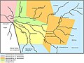 Grosspfarrei Kirchzarten.jpg 3,885 × 2,901; 748 KB
-
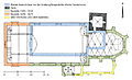 Grundriss St. Gallus Kirchzarten.jpg 3,922 × 2,375; 698 KB
-
 Innen-links St. Gallus Kirchzarten 2014.jpg 3,694 × 2,771; 1.87 MB
-
 Innen-rechta St. Gallus Kirchzarten 2014.jpg 3,085 × 2,314; 1.23 MB
-
 Inneres Portal 1880.jpg 3,091 × 4,099; 1.52 MB
-
 Inneres Portal.jpg 2,971 × 4,566; 1.58 MB
-
 Kirchzarten 1880.jpg 3,613 × 2,522; 1.36 MB
-
 Kirchzarten, die Sankt Gallus Kirche foto6 2013-07-25 14.20.jpg 3,312 × 4,416; 11.62 MB
-
 Landappbw 103210 1820 St. Gallus Kirche Kirchzarten.jpg 5,184 × 2,912; 2.24 MB
-
 Nordseite St. Gallus Kirchzarten 2014.jpg 2,492 × 3,273; 1.14 MB
-
 Orgel St. Gallus Kirchzarten 2014.jpg 4,608 × 3,456; 1.38 MB
-
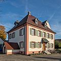
 Pfarrhaus St. Gallus (Kirchzarten) jm27330.jpg 4,015 × 4,988; 3.44 MB
-
 Pfarrhaus St. Gallus (Kirchzarten) jm27333.jpg 4,000 × 4,000; 1.85 MB
-
 Pfarrkirche Kirchzarten - geo.hlipp.de - 22521.jpg 640 × 480; 96 KB
-
 Priester St. Gallus Kirchzarten 2014.jpg 2,422 × 1,817; 926 KB
-
 Rathaus und St. Gallus Kirchzarten 2014.jpg 3,457 × 2,593; 2.39 MB
-
 St. Gallus (Kirchzarten) 7855.jpg 4,053 × 3,181; 2.78 MB
-
 St. Gallus (Kirchzarten) 7878.jpg 2,303 × 4,520; 2.23 MB
-
 St. Gallus (Kirchzarten) 7902.jpg 3,264 × 3,131; 1.36 MB
-
 St. Gallus (Kirchzarten) 7914.jpg 3,722 × 3,122; 2.23 MB
-
 St. Gallus (Kirchzarten) 7924.jpg 2,957 × 4,051; 2.72 MB
-
 St. Gallus (Kirchzarten) 7934.jpg 3,021 × 2,999; 1.52 MB
-
 St. Gallus (Kirchzarten) 7954.jpg 2,972 × 3,652; 1.7 MB
-
 St. Gallus (Kirchzarten) 7972.jpg 1,908 × 4,681; 1.95 MB
-
 St. Gallus (Kirchzarten) 7975.jpg 4,344 × 2,813; 2.3 MB
-
 St. Gallus (Kirchzarten) 7990.jpg 4,306 × 3,191; 1.65 MB
-
 St. Gallus (Kirchzarten) 7995.jpg 2,956 × 2,276; 1.06 MB
-
 St. Gallus (Kirchzarten) 8003.jpg 2,009 × 4,549; 1.45 MB
-
 St. Gallus (Kirchzarten) 8008.jpg 2,038 × 4,611; 1.35 MB
-
 St. Gallus (Kirchzarten) 8011.jpg 4,470 × 2,857; 2.13 MB
-
 St. Gallus (Kirchzarten) 8022.jpg 3,034 × 4,855; 2.6 MB
-
 St. Gallus (Kirchzarten) 8023.jpg 996 × 793; 185 KB
-
 St. Gallus (Kirchzarten) 8045.jpg 4,204 × 2,580; 1.35 MB
-
 St. Gallus (Kirchzarten) 8058.jpg 2,265 × 4,004; 1.05 MB
-
 St. Gallus (Kirchzarten) 8068.jpg 2,290 × 3,998; 1.17 MB
-
 St. Gallus (Kirchzarten) 8092.jpg 1,709 × 3,530; 646 KB
-
 St. Gallus (Kirchzarten) 8096.jpg 3,859 × 3,254; 1.3 MB
-
 St. Gallus (Kirchzarten) 8108.jpg 2,617 × 2,749; 1.18 MB
-
 St. Gallus (Kirchzarten) 8113.jpg 2,359 × 2,349; 755 KB
-
 St. Gallus (Kirchzarten) 8121.jpg 2,419 × 2,422; 1.25 MB
-
 St. Gallus (Kirchzarten) 8129.jpg 2,814 × 2,814; 1.17 MB
-
 St. Gallus (Kirchzarten) 8141.jpg 4,780 × 2,660; 2.51 MB
-
 St. Gallus (Kirchzarten) 8148.jpg 2,990 × 3,669; 1.92 MB
-
 St. Gallus (Kirchzarten) 8156.jpg 5,142 × 3,386; 1.89 MB
-
 St. Gallus (Kirchzarten) 8173.jpg 3,607 × 3,045; 1.9 MB
-
 St. Gallus (Kirchzarten) 8183.jpg 3,000 × 4,867; 2.64 MB
-
 St. Gallus (Kirchzarten) 8184.jpg 3,227 × 4,904; 3.05 MB
-
 St. Gallus (Kirchzarten) 8203.jpg 4,157 × 2,651; 1.22 MB
-
 St. Gallus (Kirchzarten) 8212.jpg 2,931 × 2,713; 1.46 MB
-
 St. Gallus (Kirchzarten) 8214.jpg 3,264 × 4,926; 2.85 MB
-
 St. Gallus (Kirchzarten) 8229.jpg 3,879 × 3,192; 1.78 MB
-
 St. Gallus (Kirchzarten) 8236.jpg 2,728 × 4,300; 2.75 MB
-
 St. Gallus (Kirchzarten) 9823.jpg 2,494 × 3,815; 888 KB
-
 St. Gallus (Kirchzarten) jm27291.jpg 3,750 × 4,403; 2.02 MB
-
 St. Gallus (Kirchzarten) jm27294.jpg 3,660 × 5,716; 3.63 MB
-
 St. Gallus (Kirchzarten) jm27321.jpg 4,000 × 6,016; 4.6 MB
-
 St. Gallus (Kirchzarten) jm27327.jpg 4,000 × 4,732; 2.21 MB
-
 St. Gallus 1880.jpg 3,594 × 2,717; 1.62 MB
-
 Südeingang St. Gallus Kirchzarten 2014.jpg 3,060 × 2,295; 1.21 MB
-
 Südseite St. Gallus Kirchzarten 2014.jpg 3,750 × 2,812; 2.24 MB
-
 Taufstein, Kirchzarten (Font) - geo.hlipp.de - 22522.jpg 480 × 640; 55 KB
-
 Ultra Bike Denkmal in Kirchzarten.jpg 1,600 × 1,200; 793 KB

.jpg)


_jm27330.jpg)
_jm27333.jpg)


_7855.jpg)
_7878.jpg)
_7914.jpg)
_7924.jpg)
_7934.jpg)
_7954.jpg)
_7975.jpg)
_7990.jpg)
_7995.jpg)
_8003.jpg)
_8008.jpg)
_8022.jpg)
_8023.jpg)
_8045.jpg)
_8058.jpg)
_8068.jpg)
_8092.jpg)
_8096.jpg)
_8108.jpg)
_8113.jpg)
_8121.jpg)
_8129.jpg)
_8141.jpg)
_8148.jpg)
_8156.jpg)
_8173.jpg)
_8183.jpg)
_8184.jpg)
_8203.jpg)
_8212.jpg)
_8214.jpg)
_8229.jpg)
_8236.jpg)
_9823.jpg)
_jm27291.jpg)
_jm27294.jpg)
_jm27321.jpg)
_jm27327.jpg)


_-_geo.hlipp.de_-_22522.jpg)

_7972.jpg)