Category:Spes Salutis (ship, 1987)
Jump to navigation
Jump to search
| Object location | | View all coordinates using: OpenStreetMap |
|---|
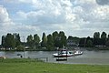
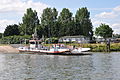
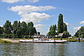
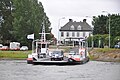
Nederlands: Afbeeldingen van het schip Spes Salutis (ship, 1987) behorende tot het Beusichemse veer, 4112 PC Beusichem. Nabij Beusichem in de provincie Gelderland in Nederland. Het Beusichemse veer vaart over de rivier de Lek richting Wijk bij Duurstede. Het Beusichemse veer is bereikbaar via de Veerweg en gelegen nabij het Veerhuis Beusichem. Tegenwoordig is er hotel en restaurant ‘t VeerHuys in gevestigd.
Media in category "Spes Salutis (ship, 1987)"
The following 9 files are in this category, out of 9 total.
-
 Beusichem. Het pontveer van Beusichem naar Wijk bij Duurstede v.v.jpg 4,770 × 3,177; 2.03 MB
-
 ENI 02317945 SPES SALUTIS (01).JPG 4,288 × 2,848; 4.5 MB
-
 ENI 02317945 SPES SALUTIS (02).JPG 4,288 × 2,848; 6.69 MB
-
 ENI 02317945 SPES SALUTIS (03).JPG 4,288 × 2,848; 5.27 MB
-
 ENI 02317945 SPES SALUTIS (04).JPG 4,288 × 2,848; 5.28 MB
-
 ENI 02317945 SPES SALUTIS (05).JPG 4,288 × 2,848; 5.03 MB
-
 ENI 02317945 SPES SALUTIS (06).JPG 4,288 × 2,848; 5.2 MB
-
 ENI 02317945 SPES SALUTIS (07).JPG 4,288 × 2,848; 5.08 MB
-
 Ferry over the Lek river near Beusichem - panoramio.jpg 4,928 × 3,264; 7.31 MB

.JPG)
.JPG)
.JPG)
.JPG)
.JPG)
.JPG)
.JPG)
