Category:Southerness
Jump to navigation
Jump to search
village in Dumfries and Galloway, Scotland, UK  | |||||
| Upload media | |||||
| Instance of | |||||
|---|---|---|---|---|---|
| Location |
| ||||
 | |||||
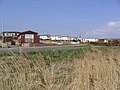
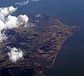
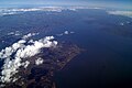
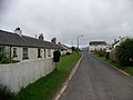
English: Southerness is a small coastal village in the South West of Scotland. Southerness is located approximately south of the A710 between Caulkerbush and Kirkbean. The town today is mainly a tourist village and has for many years had a large number of static caravans, some private and many rented to holiday makers. One of the main landmarks is its lighthouse which was built in 1749 and is one of the oldest lighthouses in Scotland. The lighthouse stands approximately 17 meters tall and was decommissioned in the 1930s. The village also has a golf course designed by Mackenzie Ross which was built in 1947.
Media in category "Southerness"
The following 59 files are in this category, out of 59 total.
-
 Algal Domes - geograph.org.uk - 1393239.jpg 640 × 436; 331 KB
-
 Algal Domes - geograph.org.uk - 1393241.jpg 640 × 480; 368 KB
-
 Algal Domes - geograph.org.uk - 1393381.jpg 640 × 388; 297 KB
-
 Beach at Southerness - geograph.org.uk - 1393237.jpg 640 × 443; 270 KB
-
 Caravan Park - geograph.org.uk - 383459.jpg 640 × 480; 101 KB
-
 Carboniferous Rocks at Southerness - geograph.org.uk - 1393231.jpg 640 × 428; 268 KB
-
 Cottages beside the shore, Southerness - geograph.org.uk - 5392123.jpg 1,600 × 1,028; 417 KB
-
 Dog walking - geograph.org.uk - 3756254.jpg 640 × 468; 113 KB
-
 Exposed rock, Southeness - geograph.org.uk - 855240.jpg 640 × 480; 94 KB
-
 Gillfoot Bay - geograph.org.uk - 5392241.jpg 1,600 × 994; 337 KB
-
 Gillfoot Bay - geograph.org.uk - 5392260.jpg 1,600 × 1,008; 263 KB
-
 High tide versus sea defences - geograph.org.uk - 3835046.jpg 640 × 424; 99 KB
-
 Late Afternoon - geograph.org.uk - 3756261.jpg 640 × 332; 52 KB
-
 Late afternoon at Southerness Lighthouse - geograph.org.uk - 6411978.jpg 1,800 × 1,200; 389 KB
-
 Lighthouse at Southerness Point - geograph.org.uk - 4217752.jpg 4,320 × 3,240; 4.91 MB
-
 Lighthouse view - geograph.org.uk - 4032706.jpg 640 × 424; 93 KB
-
 Mersehead Sands - geograph.org.uk - 2327701.jpg 640 × 427; 154 KB
-
 Oh boy, this is fun^ - geograph.org.uk - 2326250.jpg 640 × 442; 167 KB
-
 Ordnance Survey cut bench mark - geograph.org.uk - 4016234.jpg 3,648 × 2,736; 3.66 MB
-
 Parkdean Caravan Park at Southerness - geograph.org.uk - 955564.jpg 640 × 481; 56 KB
-
 Path from the beach to Shore Road - geograph.org.uk - 2483866.jpg 3,048 × 2,272; 1.11 MB
-
 Rocks at Black Craigs, Southerness - geograph.org.uk - 2327688.jpg 640 × 418; 171 KB
-

-
 Southerness - geograph.org.uk - 1393229.jpg 640 × 405; 207 KB
-
 Southerness - geograph.org.uk - 1393234.jpg 640 × 406; 236 KB
-

-
 Southerness beach - geograph.org.uk - 2483865.jpg 3,034 × 2,252; 1.48 MB
-
 Southerness golf course - geograph.org.uk - 855235.jpg 640 × 480; 64 KB
-
 Southerness Lighthouse - geograph.org.uk - 2082067.jpg 3,603 × 2,675; 238 KB
-
 Southerness Lighthouse - geograph.org.uk - 2327667.jpg 640 × 422; 157 KB
-
 Southerness Lighthouse - geograph.org.uk - 2388656.jpg 640 × 480; 63 KB
-
 Southerness Lighthouse - geograph.org.uk - 3086264.jpg 1,600 × 1,200; 314 KB
-
 Southerness Lighthouse - geograph.org.uk - 3756256.jpg 424 × 640; 90 KB
-
 Southerness lighthouse - geograph.org.uk - 4970153.jpg 3,264 × 1,836; 2.09 MB
-
 Southerness Lighthouse - geograph.org.uk - 5352316.jpg 640 × 480; 50 KB
-
 Southerness Lighthouse - geograph.org.uk - 5392067.jpg 1,600 × 1,053; 215 KB
-
 Southerness Lighthouse - geograph.org.uk - 5392076.jpg 1,046 × 1,600; 216 KB
-
 Southerness Lighthouse - geograph.org.uk - 5392109.jpg 1,027 × 1,600; 240 KB
-
 Southerness Lighthouse - geograph.org.uk - 5500664.jpg 5,104 × 3,762; 3.42 MB
-
 Southerness Lighthouse - geograph.org.uk - 5592431.jpg 3,170 × 4,750; 7.71 MB
-
 Southerness Lighthouse - geograph.org.uk - 5971713.jpg 3,456 × 4,608; 5.02 MB
-
 Southerness Lighthouse, looking east - geograph.org.uk - 2483863.jpg 2,978 × 2,174; 981 KB
-
 Southerness Lighthouse, looking southwest - geograph.org.uk - 2483860.jpg 3,054 × 2,280; 1.01 MB
-
 Southerness Point - geograph.org.uk - 1766111.jpg 2,879 × 2,592; 1.51 MB
-
 Southerness Point - geograph.org.uk - 4016269.jpg 3,648 × 2,736; 3.54 MB
-
 Southerness Point - geograph.org.uk - 462871.jpg 640 × 480; 95 KB
-
 Southerness Point and the Solway Firth - geograph.org.uk - 1766132.jpg 3,872 × 2,592; 2.09 MB
-
 Southerness Shoreline. - geograph.org.uk - 4032720.jpg 640 × 338; 109 KB
-
 Southerness. - geograph.org.uk - 12814.jpg 640 × 480; 62 KB
-
 Southwick Home Farm, Caulkerbush - geograph.org.uk - 729502.jpg 640 × 480; 117 KB
-
 The beach at Southerness - geograph.org.uk - 383025.jpg 640 × 480; 81 KB
-
 The clubhouse at Southerness Golf Course - geograph.org.uk - 383470.jpg 640 × 469; 100 KB
-
 The lighthouse at Southerness Point - geograph.org.uk - 5671384.jpg 2,592 × 1,944; 1.52 MB
-
 The main road at Southerness - geograph.org.uk - 951241.jpg 640 × 481; 54 KB
-

-
 The old lighthouse at Southerness. - geograph.org.uk - 6296184.jpg 1,024 × 683; 119 KB
-
 The rocky beach at Southerness. - geograph.org.uk - 6296186.jpg 1,024 × 683; 83 KB
-
 The shore at Southerness - geograph.org.uk - 2343005.jpg 640 × 422; 157 KB
-
 The shoreline at Southerness - geograph.org.uk - 383463.jpg 640 × 479; 103 KB


