Category:Slot Haamstede
Jump to navigation
Jump to search
| Object location | | View all coordinates using: OpenStreetMap |
|---|
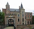
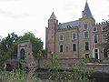
castle in the village of Haamstede on the island of Schouwen-Duiveland  | |||||
| Upload media | |||||
| Instance of | |||||
|---|---|---|---|---|---|
| Location | Ouwerkerk, Ouwerkerk | ||||
| Has part(s) | |||||
| Heritage designation |
| ||||
 | |||||
|
This is a category about rijksmonumentcomplex number 515616
|
Kasteel:
|
This is a category about rijksmonument number 515605
|
Historische aanleg:
|
This is a category about rijksmonument number 515617
|
Ruïne en keermuur:
|
This is a category about rijksmonument number 515618
|
Koetshuis:
|
This is a category about rijksmonument number 515619
|
Brug met poort:
|
This is a category about rijksmonument number 515620
|
Inrijhek en muur:
|
This is a category about rijksmonument number 515621
|
Hek:
|
This is a category about rijksmonument number 515622
|
Tuinsieraad:
|
This is a category about rijksmonument number 515623
|
| Address |
|
Subcategories
This category has the following 4 subcategories, out of 4 total.
P
S
- Slot Haamstede Behang (24 F)
- Slot Haamstede Interior (39 F)
Media in category "Slot Haamstede"
The following 106 files are in this category, out of 106 total.
-
 Aanzicht - Haamstede - 20095483 - RCE.jpg 1,200 × 1,200; 386 KB
-
 Aanzicht - Haamstede - 20095484 - RCE.jpg 1,200 × 1,200; 406 KB
-
 Aanzicht - Haamstede - 20095485 - RCE.jpg 1,200 × 1,200; 367 KB
-
 Aanzicht - Haamstede - 20095486 - RCE.jpg 1,193 × 1,200; 356 KB
-
 Achterzijde toeganspoort - Haamstede - 20095454 - RCE.jpg 1,200 × 941; 343 KB
-
 Burgh Haamstede - panoramio.jpg 676 × 507; 287 KB
-
 Burgh-Haamstede (31697736885).jpg 3,886 × 2,915; 4.05 MB
-
 Detail opgegraven gebouw - Haamstede - 20095479 - RCE.jpg 1,200 × 1,200; 382 KB
-
 DG-3-726.jpg 4,272 × 2,848; 2.74 MB
-
 Exterieur - Haamstede - 20095441 - RCE.jpg 890 × 1,200; 272 KB
-
 Exterieur - Haamstede - 20095442 - RCE.jpg 912 × 1,200; 243 KB
-
 Exterieur - Haamstede - 20095443 - RCE.jpg 884 × 1,200; 153 KB
-
 Exterieur - Haamstede - 20095444 - RCE.jpg 1,200 × 906; 227 KB
-
 Exterieur - Haamstede - 20095458 - RCE.jpg 791 × 1,200; 201 KB
-
 Exterieur vooraanzicht - Haamstede - 20095449 - RCE.jpg 947 × 1,200; 354 KB
-
 Exterieur, overzicht achterzijde - Haamstede - 20095447 - RCE.jpg 1,200 × 943; 283 KB
-
 Exterieur, overzicht achterzijde - Haamstede - 20095448 - RCE.jpg 1,200 × 940; 345 KB
-

-

-

-

-

-

-

-

-
 Funderingen poortgebouw - Haamstede - 20095459 - RCE.jpg 1,200 × 1,200; 368 KB
-
 Funderingen poortgebouw - Haamstede - 20095460 - RCE.jpg 1,200 × 1,200; 276 KB
-
 Funderingen poortgebouw - Haamstede - 20095461 - RCE.jpg 1,184 × 1,200; 383 KB
-
 Gevonden aspot - Haamstede - 20095511 - RCE.jpg 1,200 × 957; 302 KB
-
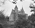
 Haamstede 13th century keep BT-006760.jpg 4,273 × 7,491; 4.08 MB
-
 Haamstede 2nd half 15th century BT-006742.jpg 6,897 × 5,262; 4.74 MB
-
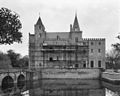
 Haamstede Castle 13th century BT-006743.jpg 5,902 × 5,063; 4.47 MB
-
 Haamstede hek.jpg 1,488 × 2,094; 531 KB
-
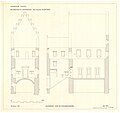
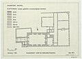 Haamstede Keep history floor plan BT-006783.jpg 4,045 × 2,910; 2.88 MB
-
 Haamstede keermuur.jpg 1,488 × 2,100; 505 KB
-
 Haamstede Slot.jpg 2,240 × 1,680; 1.57 MB
-
 Haamstede.jpg 2,106 × 1,476; 404 KB
-
 Hekpalen - Haamstede - 20095457 - RCE.jpg 831 × 1,200; 316 KB
-
 Het binnenterrein met links de poort - Haamstede - 20095534 - RCE.jpg 1,200 × 957; 263 KB
-
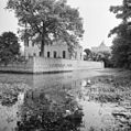
 Kademuur aan achterzijde - Haamstede - 20095452 - RCE.jpg 1,200 × 933; 374 KB
-
 Kasteel Haamstede - Haamstede - 20460440 - RCE.jpg 1,200 × 900; 217 KB
-
 Keep of Haamstede reconstruction BT-006741.jpg 5,911 × 5,569; 4.19 MB
-
 Landhoofdbrug funderingen - Haamstede - 20095462 - RCE.jpg 1,198 × 1,200; 340 KB
-
 Landhoofdbrug funderingen - Haamstede - 20095463 - RCE.jpg 1,199 × 1,200; 366 KB
-
 Linker zij- en achtergevel van het kasteel - Haamstede - 20095540 - RCE.jpg 2,416 × 3,100; 2.56 MB
-
 Noord-oost zijde - Haamstede - 20095490 - RCE.jpg 1,200 × 955; 298 KB
-
 Noord-west zijde - Haamstede - 20095488 - RCE.jpg 1,200 × 949; 229 KB
-
 Noord-west zijde - Haamstede - 20095489 - RCE.jpg 1,200 × 946; 277 KB
-
 Noord-zijde - Haamstede - 20095487 - RCE.jpg 1,200 × 956; 260 KB
-
 Ommuring noord-oost hoek - Haamstede - 20095464 - RCE.jpg 1,200 × 1,200; 298 KB
-
 Ommuring noord-oost hoek - Haamstede - 20095465 - RCE.jpg 1,200 × 1,200; 348 KB
-
 Oorlogsschade aan achtergevel - Haamstede - 20095451 - RCE.jpg 1,200 × 964; 397 KB
-
 Opgegraven bakovens - Haamstede - 20095480 - RCE.jpg 1,200 × 1,200; 376 KB
-
 Opgegraven muren noord-oost hoek - Haamstede - 20095478 - RCE.jpg 1,200 × 1,200; 328 KB
-
 Opgegraven noord-west hoekgebouw - Haamstede - 20095471 - RCE.jpg 1,200 × 1,200; 334 KB
-
 Opgegraven noord-west hoekgebouw - Haamstede - 20095472 - RCE.jpg 1,194 × 1,200; 317 KB
-
 Opgegraven noord-west hoekgebouw - Haamstede - 20095473 - RCE.jpg 1,200 × 1,189; 351 KB
-
 Opgegraven noord-west hoekgebouw - Haamstede - 20095474 - RCE.jpg 1,200 × 1,200; 365 KB
-
 Opgegraven noord-west hoekgebouw - Haamstede - 20095475 - RCE.jpg 1,193 × 1,200; 258 KB
-
 Opgegraven resten bakovens - Haamstede - 20095481 - RCE.jpg 1,200 × 1,200; 345 KB
-
 Overzicht kasteel van links voor - Haamstede - 20095446 - RCE.jpg 952 × 1,200; 279 KB
-
-

-
 Overzicht voorzijde van het kasteel - Haamstede - 20095537 - RCE.jpg 960 × 1,200; 286 KB
-
 Overzicht voorzijde van het kasteel - Haamstede - 20095538 - RCE.jpg 1,200 × 954; 281 KB
-
 Overzicht voorzijde, met poort, vanaf de straat - Haamstede - 20095445 - RCE.jpg 953 × 1,200; 365 KB
-
 Poort en brug - Haamstede - 20095535 - RCE.jpg 1,181 × 1,200; 319 KB
-
 Poort en muur langs de gracht - Haamstede - 20095536 - RCE.jpg 1,197 × 1,200; 280 KB
-
 Rechter zij- en achtergevel van het kasteel - Haamstede - 20095542 - RCE.jpg 1,185 × 1,200; 418 KB
-
 Rechter zijgevel van het kasteel - Haamstede - 20095544 - RCE.jpg 1,200 × 952; 334 KB
-
 Rechter zijgevel van het kasteel - Haamstede - 20095545 - RCE.jpg 1,200 × 956; 310 KB
-
 RM Slot Haamstede - brug met poort.JPG 4,320 × 3,240; 5.53 MB
-
 Schloss Hamstede.jpg 768 × 576; 374 KB
-
 Slot Haamstede (1).JPG 4,320 × 3,240; 5.73 MB
-
 Slot Haamstede (2).JPG 4,320 × 3,240; 4.67 MB
-
 Slot Haamstede (3).JPG 3,240 × 4,320; 4.73 MB
-
 Slot Haamstede - brug met poort (2).JPG 3,240 × 4,320; 5.7 MB
-
 Slot Haamstede - detail poort.JPG 4,320 × 3,240; 4.91 MB
-
 Slot Haamstede - hekpijler (2).JPG 3,240 × 4,320; 4.87 MB
-
 Slot Haamstede - hekpijler.JPG 3,240 × 4,320; 5.01 MB
-
 Slot Haamstede - inrij en keermuur (2).JPG 4,320 × 3,240; 5.66 MB
-
 Slot Haamstede - inrij en keermuur (3).JPG 3,240 × 4,320; 5.15 MB
-
 Slot Haamstede - inrij en keermuur.JPG 4,320 × 3,240; 5.59 MB
-
 Slot Haamstede - koetshuis.JPG 4,320 × 3,240; 5.42 MB
-
 Slot Haamstede - parkaanleg (2).JPG 4,320 × 3,240; 5.85 MB
-
 Slot Haamstede - parkaanleg (3).JPG 4,320 × 3,240; 5.84 MB
-
 Slot Haamstede - parkaanleg.JPG 4,320 × 3,240; 5.65 MB
-
 Slot Haamstede - tuinsieraden.JPG 4,320 × 3,240; 5.53 MB
-
 Slot Haamstede bloemenborder.JPG 1,600 × 1,200; 440 KB
-
 Slot Haamstede in 1743.jpg 3,663 × 2,818; 1.7 MB
-
 Slot Haamstede koetshuis.JPG 1,600 × 1,200; 421 KB
-
 Slot Haamstede laan in slotbos.JPG 1,600 × 1,200; 509 KB
-
 Slot Haamstede met poortgebouw.JPG 1,312 × 1,126; 266 KB
-
 Slot Haamstede oude kruidentuin.JPG 1,600 × 1,200; 350 KB
-
 Slot Haamstede wapen op poortgebouw.JPG 1,600 × 1,200; 358 KB
-
 Slot Haamstede.JPG 1,600 × 1,200; 303 KB
-
 Slot Haamstede.jpg 3,888 × 2,592; 3.27 MB
-
 Toegangspoort - Haamstede - 20095453 - RCE.jpg 963 × 1,200; 380 KB
-
 Toegangspoort - Haamstede - 20095482 - RCE.jpg 894 × 1,200; 271 KB
-
 Voor- en linker zijgevel van het kasteel - Haamstede - 20095539 - RCE.jpg 946 × 1,200; 343 KB
-
 Voorgevel met schade door beschieting - Haamstede - 20095450 - RCE.jpg 1,200 × 941; 251 KB
-
 Zicht op toegangspoort van kasteel - Haamstede - 20319899 - RCE.jpg 873 × 1,200; 246 KB
-
 Zij aanzicht brug - Haamstede - 20095455 - RCE.jpg 1,200 × 970; 330 KB
-
 Zij aanzicht brug - Haamstede - 20095456 - RCE.jpg 1,200 × 948; 340 KB
-
 Zuid-gevel - Haamstede - 20095491 - RCE.jpg 1,200 × 952; 285 KB
-
 Zuid-oost zijde - Haamstede - 20095492 - RCE.jpg 1,200 × 962; 329 KB


.jpg)


.JPG)
.JPG)
.JPG)
.JPG)

.JPG)

.JPG)
.JPG)


.JPG)
.JPG)


