Category:Slip lanes
Jump to navigation
Jump to search
short road at a junction that allows people to change roads without actually entering an intersection.  | |||||
| Upload media | |||||
| Subclass of |
| ||||
|---|---|---|---|---|---|
| Part of |
| ||||
| Has use |
| ||||
| |||||
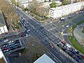
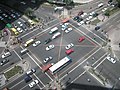
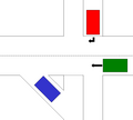
Slip lanes are right turn (or in left-hand drive countries, left turn) lanes which are separated from the remainder of an intersection by channelization islands. Often the slip lane is not signalised, while the main intersection has traffic signals. This arrangement generally improves vehicle capacity, and reduces vehicle delays, but is controversial, as the unsignalised slip lanes often see comparatively high speeds, and thus endangers pedestrians and cyclists.
Media in category "Slip lanes"
The following 16 files are in this category, out of 16 total.
-
 3 en marcha 1.JPG 1,280 × 960; 589 KB
-
 3 en marcha 2.JPG 1,280 × 960; 617 KB
-

-
 Asphalt road at Shiashie.jpg 2,322 × 4,128; 2.96 MB
-
 BAB 831 Auffahrt Stuttgart-Vaihingen.jpg 5,184 × 3,456; 8.36 MB
-
 Causeway exit to Canning Hwy.jpg 4,624 × 3,468; 7.05 MB
-
 Kreuzung-alleenring-eschersheimer-ffm001.jpg 2,848 × 2,136; 1.8 MB
-
 M1 exit sliproad, Junction 40 - geograph.org.uk - 2848241.jpg 1,024 × 768; 305 KB
-
 M62 slip road at Junction 24 to A629 at Ainley Top - geograph.org.uk - 5327367.jpg 1,917 × 1,437; 778 KB
-
 M62 to A1M north slip road - geograph.org.uk - 2739779.jpg 2,461 × 3,027; 1.01 MB
-
 Makati intersection.jpg 1,024 × 768; 93 KB
-
 Slip road on to the M606 - geograph.org.uk - 4066908.jpg 640 × 481; 65 KB
-

-
 Sliplane.png 654 × 589; 12 KB
-
 Sliproad entering Hartshead Moor Services - geograph.org.uk - 4438872.jpg 6,000 × 4,000; 5.25 MB
-


_-_geograph.org.uk_-_2514094.jpg)

