Category:Skirling
Jump to navigation
Jump to search
village in Scottish Borders, Scotland, UK  | |||||
| Upload media | |||||
| Instance of | |||||
|---|---|---|---|---|---|
| Location |
| ||||
 | |||||
Media in category "Skirling"
The following 12 files are in this category, out of 12 total.
-

-
 Approaching Howe's Brae - geograph.org.uk - 1741653.jpg 800 × 542; 140 KB
-
 Farmland near Skirling - geograph.org.uk - 169919.jpg 640 × 480; 76 KB
-
 Lanarkshire - The Red Road County - geograph.org.uk - 1182145.jpg 640 × 359; 68 KB
-
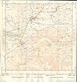 Ordnance Survey Sheet NT 03 Biggar, Published 1955.jpg 7,244 × 7,792; 14.94 MB
-
 Path to Skirling - geograph.org.uk - 724368.jpg 640 × 360; 75 KB
-
 Railings outside Skirling House - geograph.org.uk - 170457.jpg 478 × 640; 122 KB
-
 Skirling - geograph.org.uk - 170472.jpg 640 × 470; 130 KB
-
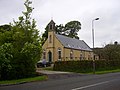 Skirling Church - geograph.org.uk - 805257.jpg 640 × 480; 74 KB
-
 Spittle Burn looking downstream - geograph.org.uk - 1726467.jpg 1,024 × 768; 288 KB
-
 Skirling - geograph.org.uk - 39902.jpg 640 × 480; 124 KB
-


