Category:Sint-Thomaskerk (Waaksens, Noardeast-Fryslân)
Jump to navigation
Jump to search
| Object location | | View all coordinates using: OpenStreetMap |
|---|
church building in Dongeradeel, Netherlands  | |||||
| Upload media | |||||
| Instance of | |||||
|---|---|---|---|---|---|
| Location | Waaxens, Noardeast-Fryslân, Friesland, Netherlands | ||||
| Street address |
| ||||
| Located on street |
| ||||
| Has part(s) | |||||
| Heritage designation |
| ||||
| Inception |
| ||||
 | |||||
Kerk:
|
This is a category about rijksmonument number 38733
|
Toren:
|
This is a category about rijksmonument number 38734
|
| Address |
|
Media in category "Sint-Thomaskerk (Waaksens, Noardeast-Fryslân)"
The following 33 files are in this category, out of 33 total.
-
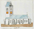 Atlas Schoemaker-FRIESLAND-DEEL1-1307RR-Friesland, Waaxens.jpeg 1,529 × 1,313; 172 KB
-
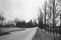 Dorpsgezicht - Waaksens - 20248415 - RCE.jpg 1,200 × 805; 224 KB
-
 Exterieur - Waaksens - 20248423 - RCE.jpg 1,200 × 804; 192 KB
-
 Familiebank aan noordwand - Waaksens - 20248455 - RCE.jpg 960 × 1,200; 219 KB
-
 Herdenkingsbord 1592 - Waaksens - 20248456 - RCE.jpg 960 × 1,200; 205 KB
-
 Hervormde kerk Waaxens.jpg 1,536 × 2,048; 1.79 MB
-

-
 Interieur naar het oosten - Waaksens - 20248419 - RCE.jpg 1,200 × 949; 224 KB
-
 Interieur naar het oosten - Waaksens - 20248420 - RCE.jpg 1,200 × 941; 212 KB
-
 Interieur naar het oosten - Waaksens - 20248453 - RCE.jpg 1,200 × 960; 182 KB
-
 Interieur naar het westen - Waaksens - 20248454 - RCE.jpg 1,200 × 960; 231 KB
-
 Interieur, aanzicht orgel, orgelnummer 1594 - Waaxens - 20417543 - RCE.jpg 800 × 1,200; 157 KB
-
 Kerk naar het westen - Waaksens - 20248416 - RCE.jpg 958 × 1,200; 316 KB
-
 Koorvenster zuid-zijde - Waaksens - 20248430 - RCE.jpg 788 × 1,200; 227 KB
-
 Linker zijgevel - Waaksens - 20248424 - RCE.jpg 1,200 × 818; 204 KB
-
 Noord ingang - Waaksens - 20248432 - RCE.jpg 1,200 × 788; 231 KB
-
 Noord koorvenster en sacristiehuis - Waaksens - 20248427 - RCE.jpg 1,200 × 788; 148 KB
-
 Noordgevel - Waaksens - 20248452 - RCE.jpg 1,200 × 960; 303 KB
-
 Overzicht - Waaksens - 20248448 - RCE.jpg 1,200 × 945; 311 KB
-
 Rechter zijgevel - Waaksens - 20248425 - RCE.jpg 1,200 × 803; 237 KB
-
 Schipvenster zuid-zijde - Waaksens - 20248431 - RCE.jpg 788 × 1,200; 247 KB
-
 Schipvenster zuid-zijde - Waaksens - 20248435 - RCE.jpg 788 × 1,200; 233 KB
-
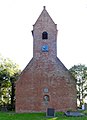
 Sint-Thomaskerk Waaxens.jpg 1,824 × 1,368; 655 KB
-
 Sint-Thomaskerk Waaxens2.jpg 1,292 × 1,780; 546 KB
-

-
 Waaksens - Sint-Tomastsjerke.jpg 2,332 × 1,679; 1.27 MB
-
 Waaksens, Sint-Thomastsjerke.jpg 2,252 × 2,252; 2.09 MB
-
 Waaksens, Sint-Tomastsjerke.jpg 2,252 × 2,251; 2.51 MB
-
 Waaksens, tsjerke en pastorij oan de Tjessenswei.jpg 2,079 × 1,440; 1.51 MB
-
 Zijaanzicht - Waaksens - 20248426 - RCE.jpg 1,200 × 803; 306 KB
-
 Zuid-oostgevel - Waaksens - 20248451 - RCE.jpg 1,200 × 960; 297 KB
-
 Zuidgevel - Waaksens - 20248449 - RCE.jpg 1,200 × 960; 342 KB
-
 Zuidgevel - Waaksens - 20248450 - RCE.jpg 1,200 × 944; 261 KB


