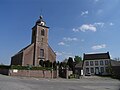
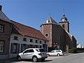
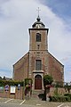
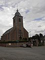
Category:Sint-Pauluskerk (Vollezele)
Jump to navigation
Jump to search
| Object location | | View all coordinates using: OpenStreetMap |
|---|
|
This is a category about Beschermd erfgoed number 12490
|
|
This is a category about onroerend erfgoed number 39123
|
church in Vollezele (Galmaarden), Belgium  | |||||
| Upload media | |||||
| Instance of | |||||
|---|---|---|---|---|---|
| Dedicated to | |||||
| Location | Vollezele, Galmaarden, Arrondissement of Halle-Vilvoorde, Flemish Brabant, Flemish Region, Belgium | ||||
| Street address |
| ||||
| Architectural style | |||||
| Diocese | |||||
| Heritage designation |
| ||||
| Inception |
| ||||
| Religion or worldview | |||||
 | |||||
Subcategories
This category has the following 2 subcategories, out of 2 total.
I
K
- Kerkhof Sint-Pauluskerk (Vollezele) (103 F)
Media in category "Sint-Pauluskerk (Vollezele)"
The following 40 files are in this category, out of 40 total.
-
 Galmaarden - Vollezele - Kerk(hof) (2011-04-18 15-39-57).jpg 3,264 × 2,448; 4.34 MB
-
 Galmaarden - Vollezele - Oudstrijdersplein zn - kerk Sint-Paulus.jpg 3,056 × 2,292; 3.44 MB
-
 Galmaarden Oudstrijdersplein 9B - 286217 - onroerenderfgoed.jpg 935 × 1,440; 264 KB
-
 Galmaarden Oudstrijdersplein 9B - 286218 - onroerenderfgoed.jpg 1,440 × 944; 320 KB
-
 Galmaarden Oudstrijdersplein 9B - 32185 - onroerenderfgoed.jpg 591 × 903; 84 KB
-
 Galmaarden Vollezele KH (1) - 306907 - onroerenderfgoed.jpg 2,736 × 3,648; 2.22 MB
-
 Galmaarden Vollezele KH (1) - 306964 - onroerenderfgoed.jpg 4,928 × 3,264; 3.9 MB
-
 Galmaarden Vollezele KH (37) - 306978 - onroerenderfgoed.jpg 3,264 × 4,928; 3.91 MB
-
 Galmaarden Vollezele KH (38) - 306985 - onroerenderfgoed.jpg 4,928 × 3,264; 4.01 MB
-
 Galmaarden Vollezele St Pauluskerk 20141201 foto105 - 307091 - onroerenderfgoed.jpg 1,920 × 2,560; 2.23 MB
-
 Galmaarden Vollezele St Pauluskerk 20141201 foto106 - 307122 - onroerenderfgoed.jpg 1,920 × 2,560; 2.2 MB
-
 Galmaarden Vollezele St Pauluskerk 20141201 foto107 - 307095 - onroerenderfgoed.jpg 1,920 × 2,560; 2.02 MB
-
 Galmaarden Vollezele St Pauluskerk 20141201 foto108 - 307085 - onroerenderfgoed.jpg 2,560 × 1,920; 2.85 MB
-
 Galmaarden Vollezele St Pauluskerk 20141201 foto120 - 307025 - onroerenderfgoed.jpg 2,560 × 1,920; 2.87 MB
-
 Galmaarden Vollezele St Pauluskerk 20141201 foto122 - 307008 - onroerenderfgoed.jpg 4,608 × 3,456; 5.68 MB
-
 Galmaarden Vollezele St Pauluskerk 20141201 foto123 - 307015 - onroerenderfgoed.jpg 4,608 × 3,456; 5.79 MB
-
 Galmaarden Vollezele St Pauluskerk 20141201 foto124 - 307017 - onroerenderfgoed.jpg 3,456 × 4,608; 5.28 MB
-
 Galmaarden Vollezele St Pauluskerk 20141201 foto125 - 307013 - onroerenderfgoed.jpg 4,608 × 3,456; 5.7 MB
-
 Galmaarden Vollezele St Pauluskerk 20141201 foto126 - 307001 - onroerenderfgoed.jpg 4,608 × 3,456; 6.16 MB
-
 Galmaarden Vollezele St Pauluskerk 20141201 foto127 - 307011 - onroerenderfgoed.jpg 3,456 × 4,608; 5.76 MB
-
 Galmaarden Vollezele St Pauluskerk 20141201 foto128 - 307021 - onroerenderfgoed.jpg 4,608 × 3,456; 6.01 MB
-
 Galmaarden Vollezele St Pauluskerk 20141201 foto129 - 307014 - onroerenderfgoed.jpg 3,456 × 4,608; 5.32 MB
-
 Galmaarden Vollezele St Pauluskerk 20141201 foto130 - 307006 - onroerenderfgoed.jpg 4,608 × 3,456; 6.37 MB
-
 Galmaarden Vollezele St Pauluskerk 20141201 foto132 - 307023 - onroerenderfgoed.jpg 4,608 × 3,456; 6.14 MB
-
 Galmaarden Vollezele St Pauluskerk 20141201 foto133 - 307010 - onroerenderfgoed.jpg 4,608 × 3,456; 6.53 MB
-
 Galmaarden Vollezele St Pauluskerk 20141201 foto134 - 307019 - onroerenderfgoed.jpg 4,608 × 3,456; 6.18 MB
-
 Galmaarden Vollezele St Pauluskerk 20141201 foto137 - 307020 - onroerenderfgoed.jpg 3,456 × 4,608; 5.35 MB
-
 Galmaarden Vollezele St Pauluskerk 20141201 foto138 - 307002 - onroerenderfgoed.jpg 3,456 × 4,608; 5.56 MB
-
 Galmaarden Vollezele St Pauluskerk 20141201 foto139 - 307007 - onroerenderfgoed.jpg 4,608 × 3,456; 6.54 MB
-
 Kerk Vollezele.jpg 682 × 1,024; 527 KB
-
 Landschap Vollezele 03.jpg 2,848 × 4,288; 2.97 MB
-
 Landschap Vollezele 04.jpg 2,848 × 4,288; 2.95 MB
-
 Landschap Vollezele 05.jpg 2,848 × 4,288; 1.8 MB
-
 Landschap Vollezele 08.jpg 2,848 × 4,288; 1.57 MB
-
 PM 134153 E Vollezele.jpg 600 × 434; 197 KB
-
 Sint-Pauluskerk Vollezele.JPG 2,736 × 3,648; 2.72 MB
-
 Vollezele Sint-Pauluskerk poort.jpg 3,456 × 5,184; 10.83 MB
-
 Vollezele Sint-Pauluskerk westgevel.jpg 3,456 × 5,184; 9.32 MB
-
 Vollezele Sint-Pauluskerk.jpg 3,456 × 5,184; 7.07 MB
-
 Vollezele-2.jpg 227 × 302; 39 KB
_(2011-04-18_15-39-57).jpg)


_-_306907_-_onroerenderfgoed.jpg)
_-_306964_-_onroerenderfgoed.jpg)
_-_306978_-_onroerenderfgoed.jpg)
_-_306985_-_onroerenderfgoed.jpg)


