Category:Sint-Agathakerk (Sint-Agatha-Rode)
Jump to navigation
Jump to search
| Object location | | View all coordinates using: OpenStreetMap |
|---|
|
This is a category about Beschermd erfgoed number 1643
|
|
This is a category about onroerend erfgoed number 43320
|
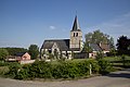
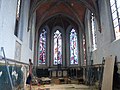
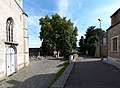
church in Huldenberg, Belgium  | |||||
| Upload media | |||||
| Instance of | |||||
|---|---|---|---|---|---|
| Dedicated to |
| ||||
| Location | Sint-Agatha-Rode, Huldenberg, Arrondissement of Leuven, Flemish Brabant, Flemish Region, Belgium | ||||
| Diocese | |||||
| Heritage designation | |||||
 | |||||
Subcategories
This category has only the following subcategory.
Media in category "Sint-Agathakerk (Sint-Agatha-Rode)"
The following 31 files are in this category, out of 31 total.
-
 -43320-Parochiekerk Sint-Agatha.jpg 4,795 × 3,197; 10.17 MB
-
 AgathaKerkSintAgathaRode.jpg 878 × 538; 139 KB
-
 België - Sint-Agatha-Rode - Sint-Agathakerk - 01.jpg 3,244 × 3,984; 9.63 MB
-
 België - Sint-Agatha-Rode - Sint-Agathakerk - 02.jpg 2,448 × 3,672; 5.82 MB
-
 België - Sint-Agatha-Rode - Sint-Agathakerk - 03.jpg 1,609 × 3,332; 4.03 MB
-
 België - Sint-Agatha-Rode - Sint-Agathakerk - 04.jpg 2,232 × 3,348; 5.37 MB
-
 Huldenberg Leuvensebaan zonder nummer - 243039 - onroerenderfgoed.jpg 1,440 × 1,080; 337 KB
-
 Huldenberg Leuvensebaan zonder nummer - 243040 - onroerenderfgoed.jpg 1,440 × 1,080; 356 KB
-
 Huldenberg Leuvensebaan zonder nummer - 243043 - onroerenderfgoed.jpg 1,440 × 1,080; 344 KB
-
 Huldenberg Leuvensebaan zonder nummer - 286853 - onroerenderfgoed.jpg 1,083 × 1,440; 494 KB
-
 Huldenberg Leuvensebaan zonder nummer - 286854 - onroerenderfgoed.jpg 1,440 × 991; 200 KB
-
 Huldenberg Leuvensebaan zonder nummer - 286855 - onroerenderfgoed.jpg 1,440 × 1,026; 302 KB
-
 Huldenberg Leuvensebaan zonder nummer - 33985 - onroerenderfgoed.jpg 591 × 423; 104 KB
-

-

-

-
 Sint-Agatha-Rode aerial photo C.jpg 7,051 × 4,705; 11.7 MB
-
 Sint-Agatha-Rode aerial photo D.jpg 7,051 × 4,705; 12.95 MB
-
 Sint-Agatha-Rode chapel B.jpg 3,008 × 2,000; 2.38 MB
-
 Sint-Agatha-Rode church A.jpg 3,693 × 2,189; 1.1 MB
-
 Sint-Agatha-Rode church B.jpg 2,798 × 1,954; 943 KB
-
 Sint-Agatha-Rode church C.jpg 3,630 × 2,211; 1.04 MB
-
 Sint-Agatha-Rode church D.jpg 5,034 × 2,970; 1.95 MB
-
 Sint-Agatha-Rode church E.jpg 3,304 × 2,436; 1.4 MB
-
 Sint-Agatha-Rode church F.jpg 1,924 × 2,692; 1.59 MB
-
 Sint-Agatha-Rode church G.jpg 3,816 × 2,064; 1.34 MB
-
 Sint-Agatha-Rode church H.jpg 3,868 × 2,180; 1.54 MB
-
 Sint-Agatha-Rode church J.jpg 1,852 × 2,697; 1.14 MB
-
 Sint-Agatha-Rode church K.jpg 1,837 × 2,225; 997 KB
-
 Sint-Agatha-Rode church L.jpg 2,816 × 1,859; 1.03 MB
-
 Sint-Agatha-Rode Kerk - panoramio.jpg 2,004 × 2,684; 584 KB


