Category:Signs in Yellowstone National Park
Jump to navigation
Jump to search
United States national parks: Acadia · Arches · Badlands · Big Bend · Black Canyon of the Gunnison · Bryce Canyon · Canyonlands · Capitol Reef · Congaree · Crater Lake · Death Valley · Denali · Everglades · Glacier · Glacier Bay · Grand Teton · Great Basin · Great Smoky Mountains · Guadalupe Mountains · Hawaii Volcanoes · Joshua Tree · Lassen Volcanic · Mesa Verde · Mount Rainier · Olympic · Petrified Forest · Pinnacles · Rocky Mountain · Sequoia · Shenandoah · White Sands · Yellowstone · Yosemite · Zion
Subcategories
This category has only the following subcategory.
E
Media in category "Signs in Yellowstone National Park"
The following 118 files are in this category, out of 118 total.
-
 "Dangerous Ground" sign (35898120631).jpg 3,667 × 4,834; 8.3 MB
-
 "Do not mark bacterial mats" sign in the Upper Geyser Basin (36031835765).jpg 5,599 × 3,733; 9.73 MB
-
 - panoramio - trukdotcom (29).jpg 960 × 1,200; 624 KB
-
 - panoramio - trukdotcom (31).jpg 960 × 1,200; 573 KB
-
 - panoramio - trukdotcom (34).jpg 1,200 × 961; 554 KB
-
 2003-08-18 Black Dragon's Caldron sign.jpg 2,536 × 1,428; 1.22 MB
-

-

-
 45eme parallele Yellowstone.jpg 3,888 × 2,592; 5.01 MB
-
 45th Parallel Sign, Yellowstone Park.jpg 800 × 532; 133 KB
-
 Albright Visitor Center, Yellowstone National Park (2021-08-09), 02.jpg 4,032 × 3,024; 4.65 MB
-
 Ashtray in Mammoth Hot Springs - No fun (2854086108).jpg 2,048 × 1,536; 637 KB
-
 Bear Country Sign for Indian Creek (14457698423).jpg 2,272 × 1,704; 2.63 MB
-
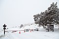
 Beautiful morning in Gardiner 2.16.17 (33436219890).jpg 8,323 × 5,549; 27.11 MB
-
 Big Cone at West Thumb Geyser Basin - Yellowstone National Park DyeClan.com - panoramio.jpg 3,264 × 2,448; 5.94 MB
-
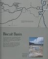 Biscuit Basin sign.JPG 857 × 1,035; 161 KB
-
 Boat permit and Yellowstone AIS inspection sign at Bridge Bay Marina (29900735538).jpg 7,879 × 5,253; 25.88 MB
-
 Boundary line between Yellowstone and Custer Gallatin National Forest (2) (36357502904).jpg 8,688 × 5,792; 27.86 MB
-
 Boundary line between Yellowstone and Custer Gallatin National Forest (37022513432).jpg 5,338 × 8,007; 28.39 MB
-
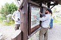
 Bulletin board in Fort Yellowstone.jpg 3,069 × 1,945; 469 KB
-

-
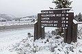
 Canyon Junction northbound sign (28133965567).jpg 7,609 × 5,073; 32.43 MB
-
 Cistern Spring (Norris Geyser Basin, Yellowstone National Park) 2021-08-09, 02.jpg 4,032 × 3,024; 4.8 MB
-
 Cistern Spring (Norris Geyser Basin, Yellowstone National Park) 2021-08-09, 03.jpg 3,024 × 4,032; 4.54 MB
-
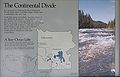
 Continental Divide in Yellowstone-750px.JPG 750 × 612; 87 KB
-
 Continental Divide in Yellowstone.JPG 1,600 × 1,200; 423 KB
-
 Continental Divide sign at Two-Ocean Lake.JPG 2,669 × 1,719; 1.03 MB
-
 Do Not Mark Bacterial Mats! (14655695940).jpg 4,608 × 3,072; 5.76 MB
-
 East Entrance Road and sign (42952924732).jpg 7,658 × 5,105; 34.34 MB
-
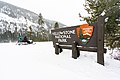
 East Entrance sign (29130276728).jpg 7,817 × 5,211; 29.81 MB
-
 Emerald Spring (Norris Geyser Basin, Yellowstone National Park) 2021-08-09, 04.jpg 4,032 × 3,024; 4.12 MB
-
 Entrance to Norris Geyser Basin (6d889626-9514-404f-8d7a-9fbd556bf71e).jpg 4,690 × 3,012; 10.52 MB
-
 Estados Unidos, carteles 1997 04.jpg 995 × 620; 559 KB
-
 Fall sunrise at Lookout Point Overlook (49015104423).jpg 8,610 × 5,740; 30.48 MB
-

-

-
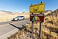 Fire Danger sign (wide) at Extreme (44738751952).jpg 7,531 × 5,021; 30.9 MB
-
 Fire Danger sign (wide) at High (43878341085).jpg 7,037 × 4,691; 28.52 MB
-
 Fire Danger sign (wide) at Low (29851644407).jpg 7,429 × 4,953; 32.96 MB
-
 Fire Danger sign (wide) at Moderate (44068635294).jpg 7,069 × 4,713; 28.78 MB
-
 Fire Danger sign (wide) at Very HIgh (44068655754).jpg 7,617 × 5,078; 31.82 MB
-
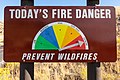 Fire Danger sign at Extreme (44068629444).jpg 7,732 × 5,155; 26.71 MB
-
 Fire Danger sign at High (43878344695).jpg 7,572 × 5,048; 25.94 MB
-
 Fire Danger sign at Low (43878349435).jpg 7,535 × 5,023; 26.9 MB
-
 Fire Danger sign at Moderate (43878353505).jpg 7,376 × 4,917; 25.54 MB
-
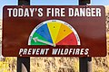
 Fire Danger sign at Very High (43878336065).jpg 7,302 × 4,868; 23.91 MB
-
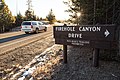 Firehole Canyon Drive sign (38265291982).jpg 8,688 × 5,792; 38.26 MB
-
 Firehole Lake Drive sign (26521645269).jpg 7,561 × 5,041; 28.12 MB
-
 Firehole Swimming Area parking lot (48441261667).jpg 7,621 × 5,081; 33.65 MB
-
 Fishing Bridge Junction westbound sign (39533852034).jpg 6,874 × 4,583; 13.1 MB
-
 Fountain Flat Drive sign (38265286452).jpg 8,688 × 5,792; 43.75 MB
-
 Grand Canyon of the Yellowstone historical marker Picture 1212.jpg 2,592 × 1,944; 1.82 MB
-
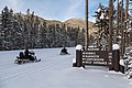
 Group arriving at Norris Geyser Basin in the winter (49266457636).jpg 8,244 × 5,496; 21.14 MB
-
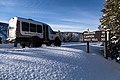
 Group walks back to the snowcoach at Norris Geyser Basin (49265981568).jpg 8,688 × 5,792; 27.88 MB
-

-
 Hurricane Vent (Norris Geyser Basin, Yellowstone National Park) 2021-08-09, 02.jpg 3,024 × 4,032; 3.88 MB
-
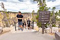
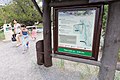
 Information sign at Inspiration Point (44385527941).jpg 5,536 × 3,691; 11.8 MB
-
 Installing the new Boiling River trailhead sign (48943686452).jpg 6,513 × 4,342; 15.43 MB
-
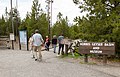
 Lewis Lake- Camping, boat ramp, picnicing (16777452241).jpg 5,184 × 3,456; 11.29 MB
-
 Madison Junction northbound sign in winter (25484868338).jpg 8,215 × 5,476; 27.28 MB
-
 Madison Junction sign (38296971421).jpg 8,306 × 5,537; 31.49 MB
-
 Madison Junction southbound sign in winter (25484884748).jpg 8,110 × 5,407; 24.47 MB
-
 Mammoth Hot Springs 2017 Instameet (38235404406).jpg 5,791 × 3,861; 13.28 MB
-
 Midway Geyser Basin sign (24426051818).jpg 8,688 × 5,792; 31.4 MB
-
 Midway Geyser Basin sign in winter (38645937254).jpg 7,940 × 5,293; 23.02 MB
-
 MK01604 Continental Divide.jpg 2,539 × 1,693; 3.74 MB
-
 MK01608 Continental Divide.jpg 1,693 × 2,539; 3.99 MB
-
 MK01618 Continental Divide.jpg 1,693 × 2,539; 4.63 MB
-
 New overlooks at Inspiration Point (2) (48324312061).jpg 7,864 × 5,243; 25.81 MB
-
 New trailhead sign at Boiling River (48942948133).jpg 7,668 × 5,112; 23.1 MB
-
 Newly-installed "One Way" sign at the Midway Geyser Basin boardwalk junction (48678730971).jpg 8,688 × 5,792; 29.76 MB
-
 Newly-renovated Uncle Tom's Point (44710727874).jpg 8,233 × 5,489; 29.64 MB
-
 Norris Junction southbound sign (26521655139).jpg 8,267 × 5,511; 35.79 MB
-
 Norris Junction southbound sign in winter (38645948524).jpg 8,065 × 5,377; 23.53 MB
-
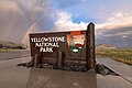 North Entrance park sign and double rainbow (48266789916).jpg 8,634 × 5,756; 22.37 MB
-
 North Entrance Road and sign (40732908573).jpg 7,819 × 5,213; 30.79 MB
-
 North Entrance sign spring 2018 (40476636700).jpg 8,071 × 5,381; 26.55 MB
-
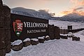 North Entrance sunset after a winter storm (26624900039).jpg 8,531 × 5,687; 27.92 MB
-
 Old Faithful eruption and sign (25176478507).jpg 8,478 × 5,652; 23.64 MB
-
 Old Faithful northbound sign (37585145524).jpg 8,032 × 5,355; 33.79 MB
-
 Old Faithful southbound sign (24426042978).jpg 6,674 × 4,449; 20.13 MB
-
 Park Entrance sign and Electric Peak (36426223132).jpg 7,480 × 4,987; 23.36 MB
-
 Park Entrance sign and Sepulcher Mountain (36426226402).jpg 8,403 × 5,602; 30.85 MB
-
 Pebble Creek Campground (34903326854).jpg 8,688 × 5,792; 40.17 MB
-
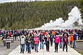 People leaving the Old Fatihful viewing area after an eruption. (34495762033).jpg 5,202 × 3,468; 13.28 MB
-
 Porcelain Springs (Norris Geyser Basin, Yellowstone National Park) 2021-08-09, 04.jpg 3,024 × 4,032; 3.02 MB
-
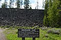 Sheepeater Cliff sign.JPG 2,048 × 1,360; 654 KB
-
 Sign at Yellowstone NP.jpg 360 × 270; 87 KB
-
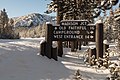
 Sign in the Pebble Creek Campground (33668695521).jpg 5,394 × 3,596; 11.38 MB
-
 Sign layout at Midway Geyser Basin (48678910542).jpg 8,688 × 5,792; 37.73 MB
-
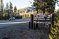
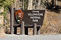 Sign near East Entrance (37899621106).jpg 4,414 × 2,926; 4.64 MB
-
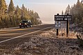
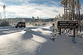
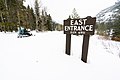 Snowmobiler rides eastboud past the East Entrance sign (49518337876).jpg 9,504 × 6,336; 24.05 MB
-
 Snowmobiler rides past the Yellowstone National Park East Entrance sign (49517811788).jpg 9,504 × 6,336; 27.31 MB
-
 Snowmobiler rides westboud past the East Entrance sign (49518336596).jpg 9,504 × 6,336; 24.08 MB
-
 Snowmobiler riding past the avalance zone sign on Sylvan Pass (49517818858).jpg 9,031 × 6,020; 17.31 MB
-
 Steamboat Geyser sign indicates last major eruption September 3, 2014 (41117653794).jpg 1,920 × 1,080; 237 KB
-
 Steamboat Geyser viewing platform (26966214737).jpg 1,920 × 1,080; 136 KB
-
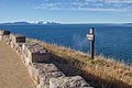 Steamboat Point (24101852308).jpg 5,184 × 3,456; 6.56 MB
-
 Step this Way... (14655548488).jpg 1,402 × 859; 695 KB
-
 Stephens Creek Corral sign (48015850588).jpg 8,434 × 5,623; 35.46 MB
-
 Sunset Lake in Black Sand Basin DyeClan.com - panoramio.jpg 2,448 × 3,264; 3.27 MB
-
 Temporary road closure at Mammoth Hot Springs (40443093491).jpg 5,760 × 3,840; 12.25 MB
-
 Tom Henderson memorial exhibit (48318835231).jpg 8,688 × 5,792; 30.6 MB
-
 Tower Junction sign after a snowstorm (26624790379).jpg 8,688 × 5,792; 30.1 MB
-
 Unmanned Aircraft Prohibited (14887809168).jpg 1,700 × 2,800; 221 KB
-
 Upper Geyser Basin northbound sign in winter (25484875028).jpg 8,364 × 5,576; 27.28 MB
-
 Virgina Cascade Drive sign (48637832952).jpg 7,573 × 5,049; 29.65 MB
-
-
 West Thumb Junction southbound sign (40341677672).jpg 8,104 × 5,403; 17.55 MB
-
 West Thumb Junction southbound sign (48637727411).jpg 7,843 × 5,229; 27.86 MB
-
 Where to next? Exploring the REI Village (29252280105).jpg 5,197 × 3,465; 14.25 MB
-
 White Dome Geyser (Lower Geyser Basin, Yellowstone National Park) 2021-08-10, 06.jpg 4,032 × 3,024; 4.68 MB
-
 Wildlife and fire danger signs at Northeast Entrance (14734278129).jpg 4,407 × 3,360; 9.3 MB
-
 Wise Advice - Flickr - brewbooks.jpg 4,608 × 3,456; 4.99 MB
-

-

-
 Yellowstone Roads and Bridges, Lake, Teton County, WY HAER WYO,20-YELNAP,9-61.tif 5,112 × 3,712; 18.1 MB
-
 Youth Conservation Corps and Expedition Yellowstone building (43845086632).jpg 7,698 × 5,132; 24.96 MB
.jpg)
.jpg)
.jpg)
.jpg)
.jpg)


,_02.jpg)
.jpg)
.jpg)
.jpg)


.jpg)
_(36357502904).jpg)
.jpg)

_Sholly_Superintendent,_Yellowstone_National_Park_-_Albright_Visitor_Center_(46028526472).jpg)
.jpg)
_2021-08-09,_02.jpg)
_2021-08-09,_03.jpg)


.jpg)
.jpg)
.jpg)
_2021-08-09,_04.jpg)
.jpg)

.jpg)
.jpg)
.jpg)
_at_Extreme_(44738751952).jpg)
_at_High_(43878341085).jpg)
_at_Low_(29851644407).jpg)
_at_Moderate_(44068635294).jpg)
_at_Very_HIgh_(44068655754).jpg)
.jpg)
.jpg)
.jpg)
.jpg)
.jpg)
.jpg)
.jpg)
.jpg)
.jpg)
.jpg)

.jpg)
.jpg)
.jpg)
_2021-08-09,_02.jpg)
.jpg)
.jpg)
.jpg)
.jpg)
.jpg)
.jpg)
.jpg)
.jpg)
.jpg)


_(48324312061).jpg)
.jpg)
.jpg)
.jpg)
.jpg)
.jpg)
.jpg)
.jpg)
.jpg)
.jpg)
.jpg)
.jpg)
.jpg)
.jpg)
.jpg)
.jpg)
.jpg)
_2021-08-09,_04.jpg)


.jpg)
.jpg)
.jpg)
.jpg)
.jpg)
.jpg)
.jpg)
.jpg)
.jpg)
.jpg)
.jpg)
.jpg)

.jpg)
.jpg)
.jpg)
.jpg)
.jpg)
.jpg)
.jpg)
.jpg)
.jpg)
.jpg)
_2021-08-10,_06.jpg)
.jpg)


.jpg)
.jpg)