Category:Shipton, Shropshire
Jump to navigation
Jump to search
village and civil parish in Shropshire, England  | |||||
| Upload media | |||||
| Instance of | |||||
|---|---|---|---|---|---|
| Location | Shropshire, West Midlands, England | ||||
 | |||||
Subcategories
This category has the following 4 subcategories, out of 4 total.
Media in category "Shipton, Shropshire"
The following 102 files are in this category, out of 102 total.
-
 Across the fields to Wenlock Edge - geograph.org.uk - 832883.jpg 640 × 480; 102 KB
-
 Approaching Shipton on the B4378 - geograph.org.uk - 1446472.jpg 640 × 480; 93 KB
-
 B4368 towards Bridgnorth - geograph.org.uk - 6107302.jpg 800 × 568; 107 KB
-
 B4368 towards Shipton - geograph.org.uk - 6107271.jpg 800 × 600; 121 KB
-
 B4378 to Much Wenlock - geograph.org.uk - 832887.jpg 640 × 480; 84 KB
-
 B4378 towards Much Wenlock - geograph.org.uk - 6107339.jpg 800 × 600; 102 KB
-
 B4378 towards Much Wenlock - geograph.org.uk - 6107351.jpg 640 × 480; 80 KB
-
 B4378 towards Much Wenlock - geograph.org.uk - 6107357.jpg 800 × 600; 106 KB
-
 B4378, Shipton - geograph.org.uk - 6107311.jpg 800 × 600; 200 KB
-
 B4378, Shipton - geograph.org.uk - 6107430.jpg 5,184 × 3,888; 7.09 MB
-
 Barley, Shipton - geograph.org.uk - 6221185.jpg 1,024 × 683; 286 KB
-
 Barn, Shipton Hall - geograph.org.uk - 6107323.jpg 800 × 600; 160 KB
-
 Brockton Primary School - geograph.org.uk - 4894797.jpg 1,200 × 799; 592 KB
-
 Brown Clee Hill - geograph.org.uk - 4903950.jpg 2,048 × 1,536; 492 KB
-
 C of E Primary school, Brockton - geograph.org.uk - 2548032.jpg 1,024 × 768; 267 KB
-
 Church of St James, Shipton - geograph.org.uk - 5999646.jpg 1,600 × 1,199; 1,001 KB
-
 Close up, Elizabeth II postbox near More Hall - geograph.org.uk - 6107437.jpg 2,058 × 2,965; 1.59 MB
-
 Close up, Elizabeth II postbox, Shipton - geograph.org.uk - 6107428.jpg 1,593 × 3,122; 1.5 MB
-
 Corve Dale farmland, Shipton - geograph.org.uk - 6221183.jpg 1,024 × 683; 313 KB
-
 Cottage, Brockton - geograph.org.uk - 6107419.jpg 5,184 × 3,888; 4.89 MB
-
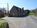 Cottages on the B4378, Shipton - geograph.org.uk - 6107327.jpg 800 × 600; 102 KB
-
 Crop field near Larden Grange - geograph.org.uk - 6107352.jpg 640 × 480; 78 KB
-
 Crossroads and tree at Brockton - geograph.org.uk - 5999637.jpg 1,600 × 1,066; 770 KB
-
 Cultivated land, Brockton - geograph.org.uk - 2126955.jpg 640 × 480; 125 KB
-
 Defibrillator, Shipton Village Hall - geograph.org.uk - 6107330.jpg 650 × 800; 124 KB
-

-
 Disused horse jumps on Mogg Forest - geograph.org.uk - 2744702.jpg 979 × 734; 464 KB
-
 Down the hill to Shipton - geograph.org.uk - 2504401.jpg 640 × 480; 80 KB
-
 Driveway from Larden Hall - geograph.org.uk - 2504408.jpg 640 × 480; 90 KB
-
 Elizabeth II postbox near More Hall - geograph.org.uk - 6107435.jpg 5,171 × 3,382; 5.54 MB
-
 Elizabeth II postbox, Brockton - geograph.org.uk - 6107416.jpg 800 × 600; 147 KB
-
 Elizabeth II postbox, Shipton - geograph.org.uk - 6107427.jpg 2,388 × 2,364; 2.02 MB
-
 Entering Brockton - geograph.org.uk - 4903930.jpg 2,048 × 1,536; 1.58 MB
-
 Entering Shipton - geograph.org.uk - 6107306.jpg 800 × 600; 167 KB
-

-
 Field, Shipton - geograph.org.uk - 5125887.jpg 4,608 × 3,456; 1.28 MB
-
 Fields sloping to the River Corve - geograph.org.uk - 5999641.jpg 1,600 × 995; 596 KB
-
 Footpath across the field - geograph.org.uk - 2340579.jpg 640 × 480; 88 KB
-
 Footpath towards Brockton - geograph.org.uk - 2340597.jpg 640 × 480; 156 KB
-
 Gate onto the B4378 at St James, Shipton - geograph.org.uk - 1446578.jpg 480 × 640; 129 KB
-
 Gated field entrance off the B4368 - geograph.org.uk - 6107280.jpg 800 × 600; 137 KB
-
 Grange Farmhouse - geograph.org.uk - 4904344.jpg 2,048 × 1,536; 1.59 MB
-
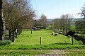
 Grazing near Meadow End - geograph.org.uk - 6107281.jpg 800 × 600; 116 KB
-
 Grazing, Corvedale - geograph.org.uk - 6107269.jpg 800 × 600; 128 KB
-
 Grazing, More Hall - geograph.org.uk - 6107344.jpg 800 × 529; 169 KB
-
 Houses on the B4368 - geograph.org.uk - 6107275.jpg 640 × 480; 70 KB
-
 Ivy Cottage, Brockton - geograph.org.uk - 2538690.jpg 1,024 × 768; 203 KB
-
 Larden Ditches hillfort - geograph.org.uk - 2746175.jpg 979 × 734; 438 KB
-
 Large crop field, Corvedale - geograph.org.uk - 6107341.jpg 800 × 600; 136 KB
-
 Large field, Shipton - geograph.org.uk - 6107337.jpg 800 × 600; 127 KB
-
 Lone tree between Shipton and Broadstone - geograph.org.uk - 5999653.jpg 1,600 × 1,203; 666 KB
-

-

-
 Looking north east on the B4368 - geograph.org.uk - 6107277.jpg 800 × 600; 91 KB
-
 Manor House, Brockton - geograph.org.uk - 3070098.jpg 3,456 × 2,304; 1.87 MB
-
 Mogg Forest trig, and a reluctant 'sit' - geograph.org.uk - 2744698.jpg 1,142 × 857; 418 KB
-
 Morehouse Farm - geograph.org.uk - 6107342.jpg 800 × 486; 82 KB
-
 Oilseed rape crop, Shipton - geograph.org.uk - 6107305.jpg 800 × 600; 186 KB
-
 Oilseed rape, Corve Dale - geograph.org.uk - 6221179.jpg 1,024 × 683; 282 KB
-
 Old barn, Shipton Hall - geograph.org.uk - 6107320.jpg 800 × 600; 138 KB
-
 Ploughed field adjacent to Stanway Coppice - geograph.org.uk - 6310303.jpg 5,184 × 3,888; 4.82 MB
-
 Road (footpath) to Larden Grange - geograph.org.uk - 6107355.jpg 800 × 600; 85 KB
-

-
 Road through Mytton Close - geograph.org.uk - 4903937.jpg 2,048 × 1,536; 1.5 MB
-
 Road to New House Farm - geograph.org.uk - 4904352.jpg 2,048 × 1,536; 1.56 MB
-
 Shipton Hall - geograph.org.uk - 3981397.jpg 5,746 × 3,300; 3.69 MB
-
 Shipton Hall - geograph.org.uk - 5798088.jpg 1,024 × 680; 270 KB
-
 Shipton Hall - geograph.org.uk - 6107319.jpg 5,184 × 3,173; 5.2 MB
-
 Shipton Hall and Stable Block - geograph.org.uk - 5798104.jpg 1,024 × 680; 260 KB
-
 Shipton Village Hall - geograph.org.uk - 1446469.jpg 640 × 446; 47 KB
-
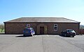 Shipton Village Hall - geograph.org.uk - 6107328.jpg 800 × 494; 66 KB
-
 Shipton Village Hall - geograph.org.uk - 6221182.jpg 1,024 × 683; 234 KB
-
 St James's Church - geograph.org.uk - 6107310.jpg 800 × 600; 222 KB
-
 St James, Shipton - geograph.org.uk - 3981830.jpg 1,761 × 1,064; 745 KB
-
 St James, Shipton - geograph.org.uk - 3982966.jpg 6,016 × 4,000; 5.97 MB
-
 St James, Shipton - geograph.org.uk - 3983061.jpg 4,813 × 3,200; 3.96 MB
-
 St James, Shipton - geograph.org.uk - 3983205.jpg 4,813 × 3,200; 3.95 MB
-
 St James, Shipton - geograph.org.uk - 3983295.jpg 3,456 × 2,592; 2.25 MB
-
 St James, Shipton - geograph.org.uk - 3983314.jpg 3,406 × 2,555; 2.88 MB
-
 St James, Shipton - geograph.org.uk - 3983350.jpg 2,518 × 3,358; 1.64 MB
-
 St James, Shipton - geograph.org.uk - 3983364.jpg 3,992 × 2,652; 1.93 MB
-
 St James, Shipton - geograph.org.uk - 3983507.jpg 6,016 × 4,000; 4.61 MB
-
 St James, Shipton - geograph.org.uk - 3983514.jpg 4,700 × 2,964; 3.91 MB
-
 Stable Block, Shipton Hall - geograph.org.uk - 3983132.jpg 4,125 × 2,572; 2.69 MB
-
 Stable Block, Shipton Hall - geograph.org.uk - 6107316.jpg 800 × 600; 114 KB
-
 Stables at Shipton Hall (geograph 5798101).jpg 1,024 × 680; 280 KB
-
 Stone cottage on the B4378 - geograph.org.uk - 6107347.jpg 800 × 600; 161 KB
-
 Stream feeding into the River Corve - geograph.org.uk - 6107270.jpg 800 × 600; 210 KB
-
 Thatched cottage - geograph.org.uk - 832882.jpg 640 × 480; 91 KB
-
 The crumbling remains of Mogg Forest cottage - geograph.org.uk - 2744699.jpg 1,142 × 857; 359 KB
-
 The Ditches hillfort on Wenlock Edge - geograph.org.uk - 2340570.jpg 640 × 480; 90 KB
-
 The Jack Mytton Way - geograph.org.uk - 832856.jpg 640 × 480; 78 KB
-

-
 Track (footpath) to Larden Hall - geograph.org.uk - 6107438.jpg 5,184 × 3,888; 7.15 MB
-
 Track to More Hall - geograph.org.uk - 6107345.jpg 800 × 600; 212 KB
-
 Trees screening More Hall from B4378 - geograph.org.uk - 5999639.jpg 1,600 × 1,143; 728 KB
-
 Un noticed - geograph.org.uk - 2585277.jpg 1,024 × 768; 180 KB
-

-
 Wooden barn in Shipton - geograph.org.uk - 5999650.jpg 1,600 × 1,143; 676 KB
-

-

-


_to_Larden_Grange_-_geograph.org.uk_-_6107355.jpg)


.jpg)


_to_Larden_Hall_-_geograph.org.uk_-_6107438.jpg)


