Category:Shikotan
Jump to navigation
Jump to search
English: Shikotan
日本語: 色丹島
Русский: Шикотан
island in South Kuril Islands   | |||||
| Upload media | |||||
| Instance of | |||||
|---|---|---|---|---|---|
| Part of | |||||
| Location | |||||
| Located in or next to body of water |
| ||||
| Mountain range |
| ||||
| Population |
| ||||
| Area |
| ||||
| Elevation above sea level |
| ||||
 | |||||
Subcategories
This category has the following 3 subcategories, out of 3 total.
Media in category "Shikotan"
The following 46 files are in this category, out of 46 total.
-
 Dajōkan fukoku 明治18年1月6日 法令全書.jpg 1,369 × 1,935; 383 KB
-
 Demis - Shikotan.png 498 × 416; 36 KB
-
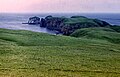
 Habomai Islands.JPG 1,000 × 630; 300 KB
-
 Hokkaido Nemuro Br 16cl.GIF 768 × 429; 7 KB
-
 Hokkaido Nemuro Br 16cl.png 768 × 429; 6 KB
-
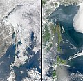
 Hokkaido Season Winter Summer 2008.png 6,216 × 1,968; 10.5 MB
-
 Hoppo.png 384 × 215; 4 KB
-
 Kunashir.jpg 987 × 628; 249 KB
-
 Kuril-Islands-Northern-Territories-of-Japan-Map.png 1,787 × 917; 415 KB
-
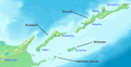
 Kuriles Shikotan.PNG 365 × 235; 4 KB
-
 North 4 islands.png 768 × 429; 13 KB
-
 Northern-Territories-of-Japan-Map-日本の北方領土の地図.png 1,787 × 917; 414 KB
-

-
 RIAN archive 50343 Pacific saury processing.jpg 691 × 1,024; 317 KB
-
 Sea Ice Surrounds Shikotan.jpg 3,727 × 3,727; 3.52 MB
-
 Sea of Okhotsk Season Winter Summer 2008.jpg 6,256 × 6,126; 8.89 MB
-
 Shikotan in Japan around 1900.png 630 × 481; 225 KB
-
 Shikotan in Nemuro Subprefecture.gif 600 × 344; 37 KB
-
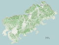
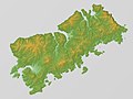 Shikotan Relief Map, SRTM-1.jpg 1,200 × 900; 417 KB
-
 Shikotan topomap.png 1,036 × 792; 473 KB
-
 ShikotanSTS112-E-5660k.PNG 4,000 × 2,000; 9.15 MB
-
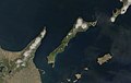
 Southern-Kuril-Islands-ISS-Space.png 1,920 × 1,080; 1.75 MB
-
 USSR map NK 55-2 Shikotan-tou.jpg 5,000 × 3,918; 1.97 MB
-
 WW - Shikotan.png 724 × 516; 717 KB
-
 Малая Курыльская града.png 400 × 540; 25 KB
-
 Маяк на острове Шикотан (Россия).jpg 1,280 × 818; 166 KB
-
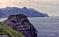
 Мыс Край Света (о.Шикотан, Курильские о-ва) Начало России на юго-востоке.jpg 1,123 × 746; 155 KB
-
 На мысе Край Света - о.Шикотан (Курильские о-ва).jpg 3,200 × 2,126; 810 KB
-
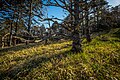 О. Шикотан Лес на утесе.jpg 5,760 × 3,840; 27.53 MB
-
 Остров Шикотан - здесь начинается Россия !.jpg 4,278 × 2,508; 2.69 MB
-
 Остров Шикотан, Малая Курильская гряда.jpg 4,000 × 3,000; 3.05 MB
-
 Остров Шикотан. Бухта Безымянная. Река течет в океан.jpg 2,000 × 1,333; 1.04 MB
-
 Остров Шикотан. Бухта Безымянная. Тихий океан.jpg 2,000 × 1,335; 2.53 MB
-
 Остров Шикотан. Бухта Крабозаводская.jpg 2,000 × 1,335; 3.31 MB
-
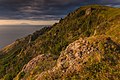
 Остров Шикотан. Мыс Край света.jpg 2,000 × 1,335; 1.88 MB
-
 Остров Шикотан. Холмы Крабозаводской бухты.jpg 2,000 × 1,335; 3.1 MB
-
 Остров Шикотан.jpg 3,052 × 1,749; 6.11 MB
-
 Проливы Курильских островов Юг.png 1,146 × 780; 616 KB
-
 Россия, Малая Курильская гряда, о.Шикотан.jpg 4,000 × 2,248; 2.24 MB
-
 Россия, Остров Шикотан.jpg 4,000 × 3,000; 2.22 MB
-
 Шикотан.jpg 991 × 633; 137 KB
-
 Шикотан3.jpg 1,280 × 819; 82 KB
-
 Шикотан4.jpg 1,280 × 818; 169 KB
-
 Шикотан5.jpg 1,280 × 819; 135 KB
-
 Шикотан6.jpg 1,280 × 802; 102 KB
-
 Я на мысе "Край Света".jpg 4,912 × 3,264; 1.1 MB


.jpg)
_%D0%9D%D0%B0%D1%87%D0%B0%D0%BB%D0%BE_%D0%A0%D0%BE%D1%81%D1%81%D0%B8%D0%B8_%D0%BD%D0%B0_%D1%8E%D0%B3%D0%BE-%D0%B2%D0%BE%D1%81%D1%82%D0%BE%D0%BA%D0%B5.jpg)
.jpg)


