Category:Shōō, Okayama
Reason: Japanese place names, including municipalities, are officially spelt without macrons; see the Gazetteer of Japan, #3262 provided by the Geospatial Information Authority of Japan
Date: tagged 4 February 2024.
Objections and discussion have their place at Category talk:Shōō, Okayama (two weeks are considered as adequate time for possible objections). See Commons:Rename a category for general information and policy.
- If the proposed rename is clearly uncontroversial or consensus-decided, place the bot command (see below) at User talk:CommonsDelinker/commands to be handled by CommonsDelinker or rename it and move the content manually. If the new destination category exists, you can remove this template, replacing it with {{category redirect|Shoo, Okayama}}.
- If the proposal is clearly or potentially controversial or requires a broader discussion, you can transfer the discussion to Commons:Categories for discussion (replacing this template with {{subst:cfd}})
- If the proposal is clearly nonsensical, mistaken or consensually rejected, please remove this template.
Warning: processing period depends on activity of Commons volunteers. Some proposals (especially with unclear reason or too weak support) stay waiting for many months to be handled.
Bot command: {{move cat|Shōō, Okayama|Shoo, Okayama|reason=Japanese place names, including municipalities, are officially spelt without macrons; see [https://www.gsi.go.jp/common/000238295.pdf the Gazetteer of Japan, #3262] provided by the Geospatial Information Authority of Japan}}
| − | Category: | + | Category:Shoo, Okayama |
| − | Category:Sh | + | Category:Shoo, Okayama |
town in Katsuta district, Okayama prefecture, Japan    | |||||
| Upload media | |||||
| Instance of | |||||
|---|---|---|---|---|---|
| Location |
| ||||
| Legal form |
| ||||
| Inception |
| ||||
| Population |
| ||||
| Area |
| ||||
| Replaces |
| ||||
| Replaced by |
| ||||
| official website | |||||
 | |||||

Subcategories
This category has the following 5 subcategories, out of 5 total.
F
- Former Katsuta County Office (3 F)
K
- Katsumada Station (17 F)
N
- Nishi-Katsumada Station (4 F)
S
- Shoo Service Area (3 F)
U
- Uetsuki Terayama Kofun (5 F)
Media in category "Shōō, Okayama"
The following 21 files are in this category, out of 21 total.
-
 Emblem of Shoo, Okayama (black).svg 491 × 393; 1 KB
-
 Emblem of Shoo, Okayama.svg 491 × 393; 1 KB
-
 Flag of Shoo Okayama.png 360 × 237; 12 KB
-
 Flag of Shoo, Okayama.svg 954 × 628; 1 KB
-
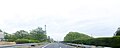 Fukuyoshi Shootown Okayamapref Chugoku Expressway.JPG 1,483 × 589; 403 KB
-
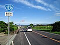
 Japan National Route 179 -03.jpg 2,592 × 1,944; 1.28 MB
-
 Japan National Route 429 -06.jpg 2,592 × 1,944; 1.08 MB
-
 Japan National Route 429 -08.jpg 2,592 × 1,944; 1.24 MB
-
 JRW katsumada sta2.jpg 5,184 × 3,456; 12.5 MB
-
 Kan-on-ji (Sho-o), sanmon.jpg 6,010 × 3,990; 8.62 MB
-
 Map Shouou en,.png 1,281 × 901; 49 KB
-
 Okayama Prefectural Road Route 52 in Shoo -01.jpg 2,560 × 1,920; 2.63 MB
-
 Population distribution of Shouou, Okayama, Japan.svg 512 × 256; 22 KB
-
 Route179 Shouou.jpg 1,536 × 1,152; 603 KB
-
 Shoo Okayama chapter.JPG 212 × 175; 12 KB
-
 Shoo town office.jpg 1,600 × 1,200; 721 KB
-
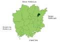
 Shouou in Okayama Prefecture Ja.svg 456 × 536; 10 KB
-
 勝央町勝間田 - panoramio.jpg 1,600 × 900; 191 KB
-
 勝央町小矢田 - panoramio.jpg 1,600 × 900; 228 KB
-
 国道179号線 - panoramio.jpg 1,600 × 900; 205 KB
-
 栗柄神社.jpg 3,935 × 3,022; 5.79 MB
.svg)


,_sanmon.jpg)


