Category:September 2007 in County Armagh
Jump to navigation
Jump to search
English: Images taken in County Armagh, Northern Ireland in this month of 2007 (not the date of the upload).
| Jan | Feb | Mar | Apr | May | Jun | Jul | Aug | Sep | Oct | Nov | Dec | ||
| ← | 10 | 12 | 6 | 2 | 15 | 0 | 15 | 40 | 84 | 75 | 135 | 1 | → |
|---|
Media in category "September 2007 in County Armagh"
The following 84 files are in this category, out of 84 total.
-

-
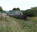 A passing steam train - geograph.org.uk - 557045.jpg 640 × 558; 120 KB
-
-

-
 Ahorey Presbyterian Church Hall - geograph.org.uk - 552408.jpg 640 × 480; 49 KB
-
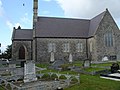 Annaghmore Parish Church - geograph.org.uk - 568813.jpg 640 × 480; 100 KB
-
 Annagora Road, Portadown. - geograph.org.uk - 552271.jpg 640 × 480; 99 KB
-
 Annahugh Road, Loughgall. - geograph.org.uk - 556085.jpg 640 × 480; 68 KB
-

-

-

-
 Apple Orchard, Tullymore Road, Loughgall. - geograph.org.uk - 556073.jpg 640 × 480; 111 KB
-
 Ardmore Church - geograph.org.uk - 542135.jpg 480 × 640; 63 KB
-
 Ardmore Church - geograph.org.uk - 542191.jpg 480 × 640; 77 KB
-
 Armagh Elim Church. - geograph.org.uk - 552217.jpg 640 × 480; 58 KB
-

-
-
 Ballygassey Road, Loughgall. - geograph.org.uk - 552260.jpg 640 × 480; 97 KB
-
 Ballynarry Road Junction - geograph.org.uk - 568709.jpg 640 × 480; 108 KB
-
 Banks of the river Bann - geograph.org.uk - 542164.jpg 480 × 640; 117 KB
-
 Bannfoot Ferry (West) - geograph.org.uk - 568703.jpg 640 × 480; 95 KB
-
 Bannfoot Ferry (West) - geograph.org.uk - 568706.jpg 640 × 480; 130 KB
-
 Belmont Road - geograph.org.uk - 568746.jpg 640 × 480; 84 KB
-
 Belmont Road Apple Trees - geograph.org.uk - 568749.jpg 640 × 480; 165 KB
-
 Bramley orchard, Cranagill - geograph.org.uk - 592236.jpg 640 × 480; 129 KB
-
 Breagh Church hall - geograph.org.uk - 553427.jpg 640 × 480; 85 KB
-
 Bridge on Derrykeeran Road - geograph.org.uk - 553419.jpg 640 × 405; 69 KB
-
 Bridge on Farlough Road. - geograph.org.uk - 553414.jpg 640 × 480; 98 KB
-
 Cabragh Road, Tandragee. - geograph.org.uk - 561888.jpg 640 × 480; 84 KB
-
 Camlough Quarry - geograph.org.uk - 555475.jpg 600 × 450; 93 KB
-
 Cannagola Road Railway Bridge - geograph.org.uk - 568829.jpg 640 × 480; 114 KB
-
 Carrick Road Junction - geograph.org.uk - 568610.jpg 640 × 480; 95 KB
-
 Castleraw Road, Loughgall. - geograph.org.uk - 556139.jpg 640 × 480; 105 KB
-
 Cladymore Presbyterian Church - geograph.org.uk - 547709.jpg 640 × 480; 99 KB
-
 Clantilew Road Railway Bridge - geograph.org.uk - 568827.jpg 480 × 640; 159 KB
-
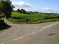
 Clonmacash and Eglish Road Junction - geograph.org.uk - 568755.jpg 640 × 480; 73 KB
-
 Clonmacash Road end - geograph.org.uk - 568743.jpg 640 × 480; 93 KB
-
 Cordrain Road, Tandragee. - geograph.org.uk - 561122.jpg 640 × 480; 68 KB
-
 Country Crossing - geograph.org.uk - 568823.jpg 640 × 480; 153 KB
-
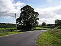
 Country Idyll - geograph.org.uk - 568686.jpg 640 × 480; 170 KB
-
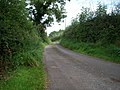
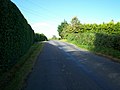
 Country Lane - geograph.org.uk - 568735.jpg 640 × 480; 84 KB
-
 Creenagh Road, Loughgall. - geograph.org.uk - 552255.jpg 640 × 480; 111 KB
-
 Cushenny Road - geograph.org.uk - 567835.jpg 640 × 480; 134 KB
-
 Derrycor and Clonmacash Road Junction - geograph.org.uk - 568740.jpg 640 × 480; 103 KB
-
 Derrycrew Farm Road - geograph.org.uk - 568833.jpg 640 × 480; 89 KB
-
 Derrymacfell Road - geograph.org.uk - 568590.jpg 640 × 480; 112 KB
-

-
 Drumnevan Road - Dismantled Bridge - geograph.org.uk - 568731.jpg 640 × 480; 96 KB
-
 Drumnevan Road - geograph.org.uk - 568732.jpg 640 × 480; 114 KB
-

-
 Entering Darkley - geograph.org.uk - 568255.jpg 480 × 640; 72 KB
-
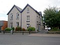
 Former Church Street School. - geograph.org.uk - 568306.jpg 640 × 480; 70 KB
-
 Galbraith's Bridge - geograph.org.uk - 568259.jpg 640 × 480; 109 KB
-

-

-
 House at Derryloste - geograph.org.uk - 568490.jpg 640 × 480; 70 KB
-
 Junction of Keady road-Dundrum Road - geograph.org.uk - 568250.jpg 640 × 480; 85 KB
-
-

-
 Keady Road (A29) - geograph.org.uk - 568275.jpg 640 × 429; 71 KB
-
 Licensed Premises (Long since closed) - geograph.org.uk - 547717.jpg 640 × 516; 118 KB
-
 Location of Bannfoot ferry - geograph.org.uk - 541968.jpg 640 × 480; 111 KB
-
 Lower Slopes of Slieve Gullion - geograph.org.uk - 564011.jpg 640 × 480; 78 KB
-
 Maghery Canal - geograph.org.uk - 563261.jpg 640 × 480; 75 KB
-
 Maghery Canal 2 - geograph.org.uk - 563283.jpg 640 × 480; 98 KB
-
 Moy Road, B28 - geograph.org.uk - 567846.jpg 640 × 480; 69 KB
-
 Mullahead Road, Portadown. - geograph.org.uk - 565186.jpg 640 × 480; 84 KB
-
 North East of Slieve Gullion - geograph.org.uk - 564032.jpg 640 × 480; 127 KB
-
 North Western slope of Slieve Gullion - geograph.org.uk - 564342.jpg 640 × 438; 55 KB
-

-

-

-

-
 Realigned Grange Road, Loughgall. - geograph.org.uk - 556063.jpg 640 × 480; 65 KB
-
-

-
 Routemaster in Portadown.jpg 640 × 480; 79 KB
-
 Sheep, Slieve Gullion - geograph.org.uk - 564006.jpg 640 × 480; 104 KB
-
 Slieve Gullion - summit - geograph.org.uk - 563994.jpg 640 × 480; 96 KB
-

-
 Tassagh Gospel Hall - geograph.org.uk - 568213.jpg 640 × 480; 69 KB
-
 Tassagh Viaduct - geograph.org.uk - 568246.jpg 640 × 480; 81 KB
-
 The Cooley Hill Road, Tandragee. - geograph.org.uk - 561120.jpg 640 × 480; 68 KB
-


_-_geograph.org.uk_-_568703.jpg)
_-_geograph.org.uk_-_568706.jpg)


_-_geograph.org.uk_-_568275.jpg)
_-_geograph.org.uk_-_547717.jpg)


,_Sandymount_Road,_Loughgall_-_geograph.org.uk_-_552251.jpg)


