Category:Sendemast 17 des Senders Königs Wusterhausen
Jump to navigation
Jump to search
| Object location | | View all coordinates using: OpenStreetMap |
|---|
 | |||||
| Upload media | |||||
| Instance of | |||||
|---|---|---|---|---|---|
| Location | Königs Wusterhausen radio transmitter, Königs Wusterhausen, Dahme-Spreewald District, Brandenburg, Germany | ||||
| Inception |
| ||||
| Height |
| ||||
 | |||||
Media in category "Sendemast 17 des Senders Königs Wusterhausen"
The following 13 files are in this category, out of 13 total.
-
 Aufblick Sendemast KW13072023.png 3,372 × 5,058; 24.07 MB
-
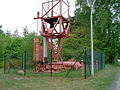
 Fuss Sendemast KW13072023.png 3,371 × 5,049; 31 MB
-
 Gewichtablage Sendemast KW13072023.png 3,303 × 4,979; 35.15 MB
-
 Koenigswusterhausen Ardea cinerea and radio mast 04.12.2010 18-00-06.JPG 3,104 × 4,672; 7.99 MB
-
 Koenigswusterhausen Selbststrahlender Sendemast Denis Apel.JPG 640 × 480; 138 KB
-
 Mannschaftsgebaeude und Mast 17 auf dem Funkerberg.jpg 3,057 × 4,934; 5.2 MB
-
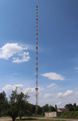
 Mast-17 Sendemast Koenigs Wusterhausen.jpg 2,010 × 3,036; 3.34 MB
-
 Mobilfunkturm KW13072023 3.png 3,017 × 4,825; 18.39 MB
-
 Selbststrahlender Sendemast 1.JPG 640 × 480; 167 KB
-
 Sendemast 17 auf dem "Funkerberg" (HDR) - panoramio.jpg 2,704 × 13,126; 9.15 MB
-
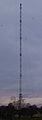 Sendemast 17 auf dem "Funkerberg" in Königs Wusterhausen - panoramio.jpg 2,451 × 7,026; 508 KB
-
 Sendemast Koenigswusterhausen.jpg 1,200 × 1,600; 623 KB
-
 Sendemast KW13072023 1.png 3,225 × 4,971; 22.62 MB


_-_panoramio.jpg)