Category:Seeweiher Grotte
Jump to navigation
Jump to search
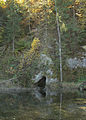
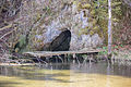
Deutsch: Seeweihergrotte (HFA-Katasternummer: D 68) im Veldensteiner Forst
Geotop in Landkreis Bayreuth in Bavaria, Germany  | |||||
| Upload media | |||||
| Instance of | |||||
|---|---|---|---|---|---|
| Location | Veldensteiner Forst, Bayreuth, Upper Franconia, Bavaria, Germany | ||||
| Heritage designation | |||||
| Width |
| ||||
| Length |
| ||||
| Area |
| ||||
| Elevation above sea level |
| ||||
| official website | |||||
 | |||||
This category shows the natural monument in Veldensteiner Forst in Bavaria with the ID 41/17 and the name Seeweiherquellgrotte D 68.
|
 |
 |
Media in category "Seeweiher Grotte"
The following 5 files are in this category, out of 5 total.
-
 Estavelle Seeweiherquelle01 (cropped).jpg 2,295 × 1,739; 1.91 MB
-
 Estavelle Seeweiherquelle02 (cropped).jpg 1,357 × 1,900; 1.3 MB
-
 Seeweiher 2015 05.jpg 5,184 × 3,456; 4.54 MB
-
 Seeweiher 2015 07.jpg 5,184 × 3,456; 6.86 MB
-
 Seeweiherquelle01.jpg 4,290 × 2,856; 5.71 MB
.jpg)
.jpg)


Categories:
- Natural monuments in Landkreis Bayreuth
- Caves of Karstgebiet D
- Geotopes in Landkreis Bayreuth
- Springs of Upper Franconia
- Estavelle
- Seeweiher (Veldensteiner Forst)
- Naturschutzgebiet Pegnitzau zwischen Ranna und Michelfeld
- Landschaftsschutzgebiet Fränkische Schweiz - Veldensteiner Forst im Regierungsbezirk Oberfranken
- Geotopes in Naturpark Fränkische Schweiz-Veldensteiner Forst
- Caves in Naturpark Fränkische Schweiz-Veldensteiner Forst
- Bodies of water in Naturpark Fränkische Schweiz-Veldensteiner Forst