Category:Sea wall north of Canning Island
Jump to navigation
Jump to search
| Object location | | View all coordinates using: OpenStreetMap |
|---|
wall in Liverpool, Merseyside, UK  | |||||
| Upload media | |||||
| Instance of | |||||
|---|---|---|---|---|---|
| Location | Liverpool, Merseyside, North West England, England | ||||
| Heritage designation |
| ||||
 | |||||
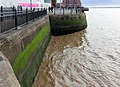
Grade II listed seawall at the entrance to Canning Half-Tide Dock built 1844 by Jesse Hartley in granite rubble blocks of varying sizes..
Media in category "Sea wall north of Canning Island"
The following 2 files are in this category, out of 2 total.
-
 Sea wall north of Canning Island 1.jpg 4,484 × 3,265; 9.53 MB
-
 Sea wall north of Canning Island 2.jpg 4,917 × 3,260; 9.99 MB
