Category:Schutter (Danube)
Jump to navigation
Jump to search
| Object location | | View all coordinates using: OpenStreetMap |
|---|
river in Germany  | |||||
| Upload media | |||||
| Instance of | |||||
|---|---|---|---|---|---|
| Location | Bavaria, Germany | ||||
| Length |
| ||||
| Mouth of the watercourse | |||||
| Drainage basin | |||||
| Tributary |
| ||||
 | |||||
Media in category "Schutter (Danube)"
The following 13 files are in this category, out of 13 total.
-
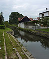
 Die Schutter in Ingolstadt.jpg 4,000 × 3,000; 1.83 MB
-
 Kaponniere 94 in Ingolstadt.jpg 8,256 × 5,504; 11.33 MB
-
 Kaponniere 94.jpg 8,256 × 5,504; 11.45 MB
-
 Kunstwerk Schuttersteg unterer Teil.jpg 8,256 × 5,504; 11.85 MB
-
 Kunstwerk Schuttersteg.jpg 5,504 × 8,256; 12.29 MB
-
 Künettegraben mit Abfluss der Schutter beim Kaponniere 94.jpg 8,256 × 5,504; 11.55 MB
-
 Nassenfels Schutter.jpg 2,399 × 2,919; 953 KB
-
 Schutter Donau catchment.png 1,200 × 609; 1.3 MB
-
 Schutter.JPG 2,816 × 2,112; 2.76 MB
-
 Schuttermündung am linken Donauufer.jpg 8,256 × 5,504; 9.04 MB
-
 Schuttermündung in die Donau.jpg 5,504 × 8,256; 10.07 MB
-
 Schuttermündung vom gegenüberliegenden Ufer aus fotografiert.jpg 8,256 × 5,504; 10.87 MB
-
 Störche an der Schutter.jpg 4,000 × 3,000; 1.93 MB


