Category:Schrotturm, Klagenfurt
Jump to navigation
Jump to search
| Object location | | View all coordinates using: OpenStreetMap |
|---|
 | |||||
| Upload media | |||||
| Instance of | |||||
|---|---|---|---|---|---|
| Location | Klagenfurt, Carinthia, Austria | ||||
| Street address |
| ||||
| Heritage designation | |||||
 | |||||
Media in category "Schrotturm, Klagenfurt"
The following 8 files are in this category, out of 8 total.
-
 Klagenfurt Gurliltsch Hauptstrasse Schrotturm 16112008 26.jpg 2,848 × 4,288; 3.64 MB
-
 Klagenfurt Gurlitsch Friedelstrand Schrotturm 23092013 9941.jpg 4,928 × 3,264; 9.06 MB
-
 Klagenfurt Gurlitsch Friedelstrand Schrotturm 23092013 9954.jpg 4,928 × 3,264; 9.14 MB
-
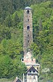
 Klagenfurt Gurlitsch Schrotturm 13042013 044.jpg 3,264 × 4,928; 2.12 MB
-
 Klagenfurt Gurlitsch Schrotturm 13042013 077.jpg 3,264 × 4,928; 1.87 MB
-
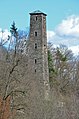
 Schrottenturm , Klagenfurt.jpg 1,657 × 2,531; 3.84 MB
-
 Schrottenturm.JPG 2,592 × 3,888; 5.22 MB
-
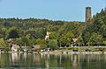
 Wörthersee Kärnten.jpg 4,672 × 2,721; 8.08 MB


Categories:
- Buildings in Klagenfurt
- Cultural heritage monuments in Klagenfurt
- Cultural heritage monuments in Carinthia in bad condition
- Industrial heritage in Carinthia
- Shot towers in Austria
- St. Martin (Klagenfurt am Wörthersee)
- Towers in Carinthia
- Stone towers in Austria
- Tetragonal towers in Austria
- 67-meter-tall buildings