Category:Schoolstraat 31, Jistrum
Jump to navigation
Jump to search
| Object location | | View all coordinates using: OpenStreetMap |
|---|
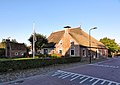
farmhouse in Tytsjerksteradiel, Netherlands  | |||||
| Upload media | |||||
| Instance of | |||||
|---|---|---|---|---|---|
| Location | Jistrum, Tytsjerksteradiel, Friesland, Netherlands | ||||
| Street address |
| ||||
| Located on street |
| ||||
| Heritage designation |
| ||||
 | |||||
|
This is a category about rijksmonument number 35647
|
| Address |
|
Media in category "Schoolstraat 31, Jistrum"
The following 12 files are in this category, out of 12 total.
-
 - Boerderij 1 - Schoolstraat 31, Jistrum.jpg 4,608 × 3,456; 5.39 MB
-
 - Boerderij 2 - Schoolstraat 31, Jistrum.jpg 4,608 × 3,456; 5.52 MB
-
 - Boerderij 3 - Schoolstraat 31, Jistrum.jpg 4,608 × 3,456; 6.7 MB
-
 - Boerderij 4 - Schoolstraat 31, Jistrum.jpg 3,456 × 4,608; 4.94 MB
-
 - Boerderij 5 - Schoolstraat 31, Jistrum.jpg 3,456 × 4,608; 4.66 MB
-
 - Boerderij 6 - Schoolstraat 31, Jistrum.jpg 3,456 × 4,608; 5.99 MB
-
 - Boerderij 7 - Schoolstraat 31, Jistrum.jpg 4,219 × 3,167; 5.13 MB
-
 - Boerderij 8 - Schoolstraat 31, Jistrum.jpg 4,608 × 3,456; 5.32 MB
-
 31, aanzicht - Eestrum - 20067843 - RCE.jpg 1,200 × 811; 226 KB
-
 Jistrum, Skoalstrjitte 31.jpg 2,642 × 1,762; 1.46 MB
-
 Schoolstraat 31 Jistrum.jpg 1,797 × 1,278; 428 KB
-
 Schoolstraat 31, Eestrum.JPG 4,032 × 3,024; 2.48 MB


