Category:Schokland
Jump to navigation
Jump to search
|
This place is a UNESCO World Heritage Site, listed as
Schokland and Surroundings.
|
former island in the Dutch Zuiderzee that is located in the municipality Noordoostpolder  The elevation of the former island is clearly visible | |||||
| Upload media | |||||
| Instance of | |||||
|---|---|---|---|---|---|
| Location |
| ||||
| Heritage designation |
| ||||
| Population |
| ||||
| Area |
| ||||
| official website | |||||
 | |||||
Subcategories
This category has the following 14 subcategories, out of 14 total.
A
B
C
- Cemeteries on Schokland (1 F)
- Countryside in Schokland (82 F)
E
H
M
- Maps of Schokland (29 F)
P
S
- Schokkerbuurt (4 F)
T
V
Media in category "Schokland"
The following 29 files are in this category, out of 29 total.
-
 8319 Schokland, Netherlands - panoramio.jpg 2,048 × 1,375; 492 KB
-
-
 Kampen, het Schokkermonument foto3 2016-02-17 13.26.jpg 4,221 × 2,485; 6.26 MB
-
 Kerkje op Schokland, Bestanddeelnr 902-5431.jpg 3,251 × 2,538; 1.3 MB
-
 Kerkje op Schokland, Bestanddeelnr 902-5432.jpg 2,529 × 3,245; 1.19 MB
-
 Port Emmeloord 19-20e Schokland haven.jpg 896 × 447; 67 KB
-
 Profielen - nog - 30034343 - RCE.jpg 1,200 × 808; 133 KB
-
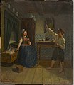
 Schokkers, aquarelle de Gerrit Jan Smit, 1870 02.jpg 689 × 456; 83 KB
-
 Schokland 'De Oude Haven' (540930264).jpg 514 × 768; 64 KB
-
 Schokland 'De Oude Haven' (541038795).jpg 1,024 × 654; 244 KB
-
 Schokland 'De Oude Haven' (541039011).jpg 1,024 × 685; 211 KB
-
 Schokland 'De Oude Haven' (541039153).jpg 506 × 768; 120 KB
-
 Schokland 'De Oude Haven' (541039233).jpg 1,024 × 648; 181 KB
-
 Schokland - museumkerkje 2011-12.jpg 3,888 × 2,592; 3.99 MB
-
 Schokland 138.JPG 3,264 × 2,448; 2.13 MB
-
 Schokland in 1907.jpg 1,276 × 852; 159 KB
-
 Schokland werelderfgoed hnapel 004.jpg 4,342 × 6,077; 5.8 MB
-
 Schokland werelderfgoed hnapel 005.jpg 7,198 × 4,196; 7.65 MB
-
 Schokland werelderfgoed hnapel 010.jpg 7,177 × 4,453; 7.21 MB
-
 Schokland werelderfgoed hnapel 011.jpg 7,208 × 4,400; 7 MB
-
 Schokland werelderfgoed hnapel 012.jpg 7,346 × 4,673; 8.41 MB
-
 Schokland werelderfgoed hnapel 013.jpg 7,360 × 4,615; 8.82 MB
-
 Schokland werelderfgoed hnapel 014.jpg 6,834 × 3,944; 6.27 MB
-
 Schokland werelderfgoed hnapel 016.jpg 7,360 × 4,285; 8.35 MB
-

-
 View from Schokland 3.JPG 3,264 × 2,448; 839 KB
-
 View from Schokland 4.JPG 3,264 × 2,448; 766 KB
-
 View from Schokland 5.JPG 2,448 × 3,264; 321 KB
-
 Wateroverlast Noordoostpolder 6-11-1998-26.jpg 471 × 311; 82 KB


.jpg)
.jpg)
.jpg)
.jpg)
.jpg)


