Category:Schloss Fürstlich Drehna
Jump to navigation
Jump to search
| Object location | | View all coordinates using: OpenStreetMap |
|---|
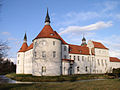
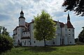
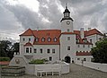
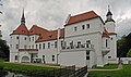
This is the category of the Brandenburger Baudenkmal (cultural heritage monument) with the ID 09140056 (Wikidata)
|
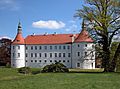
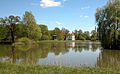
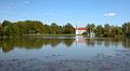
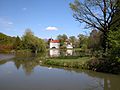
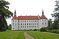
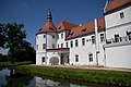
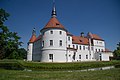
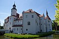
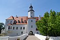
water castle in Luckau, Germany  | |||||
| Upload media | |||||
| Instance of | |||||
|---|---|---|---|---|---|
| Location | Luckau, Dahme-Spreewald District, Brandenburg, Germany | ||||
| Heritage designation | |||||
 | |||||
Media in category "Schloss Fürstlich Drehna"
The following 51 files are in this category, out of 51 total.
-
 100, Schloss "Fürstlich Drehna" - panoramio.jpg 4,288 × 3,216; 3.59 MB
-
 20150429300MDR.JPG Fürstlich Drehna Schloß.jpg 5,060 × 2,690; 7.01 MB
-
 20150429305MDR.JPG Fürstlich Drehna Schloß.jpg 4,044 × 2,223; 6.26 MB
-
 20150429315MDR.JPG Fürstlich Drehna Schloß.jpg 3,504 × 2,073; 4.01 MB
-
 20150429325DR.JPG Fürstlich Drehna Schloß.jpg 2,484 × 1,832; 3.18 MB
-
 20150429345DR.JPG Fürstlich Drehna Schloß.jpg 2,437 × 1,802; 3.33 MB
-
 20150429350DR.JPG Fürstlich Drehna Schloß.jpg 2,560 × 1,586; 2.69 MB
-
 20150429360DR.JPG Fürstlich Drehna Schloß.jpg 2,560 × 1,860; 2.87 MB
-
 20150429375DR.JPG Fürstlich Drehna Schloß.jpg 2,560 × 1,404; 2.26 MB
-
 20150429380DR.JPG Fürstlich Drehna Schloß.jpg 2,560 × 1,911; 2.92 MB
-
 20150429385DR.JPG Fürstlich Drehna Schloß.jpg 2,560 × 1,920; 2.92 MB
-
 20150429400MDR.JPG Fürstlich Drehna Schloß.jpg 2,417 × 1,944; 3.12 MB
-
 20150429405MDR.JPG Fürstlich Drehna Schloß.jpg 4,290 × 2,652; 5.73 MB
-
 20150429410DR.JPG Fürstlich Drehna Schloß.jpg 2,428 × 1,860; 3.27 MB
-
 20150429420DR.JPG Fürstlich Drehna Schloß.jpg 2,334 × 1,758; 2.79 MB
-
 Drehna, Brandenburg - Schloss (back) (Zeno Ansichtskarten).jpg 2,152 × 1,377; 109 KB
-
 Drehna, Brandenburg - Schloss (Zeno Ansichtskarten).jpg 2,159 × 1,383; 354 KB
-
 F Drehna Ostseite 800px.jpg 800 × 600; 167 KB
-
 F Drehna Südwestseite 800px.jpg 800 × 599; 113 KB
-
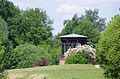
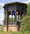 Fuerstlich Drehna Pavillon.jpg 1,200 × 1,350; 309 KB
-
 Fuerstlich Drehna Schloss 01.JPG 4,933 × 3,224; 8.99 MB
-
 Fürstlich Drehna Schloss Lindenplatz Luckau.jpg 2,469 × 1,635; 2.78 MB
-
 Fürstlich Drehna Schloss Park.jpg 2,469 × 1,635; 3.35 MB
-
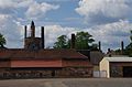 Fürstlich Drehna Wirtschaftshof.jpg 2,469 × 1,635; 2.62 MB
-
 Fürstlich-Drehna-Schloss-1.jpg 3,648 × 2,650; 1.81 MB
-
 Fürstlich-Drehna-Schloss-2.jpg 4,543 × 2,695; 2.19 MB
-
 Fürstlich-Drehna-Schloss-3.jpg 3,370 × 2,528; 1.59 MB
-
 Fürstlich-Drehna-Schloss-4.jpg 3,186 × 2,124; 1.94 MB
-
 Fürstlich-Drehna-Schloss-5.jpg 3,648 × 2,611; 1.45 MB
-
 Fürstlich-Drehna-Schlossbrücke.jpg 3,483 × 2,612; 1.6 MB
-
 Gutshof Fürstlich Drehna.jpg 4,608 × 2,592; 6 MB
-

-
 Hochwertig sanierte Schlossanlage in Fürstlich Drehna - Lausitz, Brandenburg..JPG 4,000 × 3,000; 2.56 MB
-
 Lausitz A.jpg 615 × 461; 93 KB
-
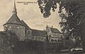
 Schloss Fuerstlich Drehna Sammlung Duncker.jpg 1,114 × 830; 247 KB
-
 Schloss Fürst. Drehna Amtshaus.jpg 4,608 × 2,592; 4.48 MB
-
 Schloss Fürstlich Drehna 2022CF 01.jpg 6,016 × 4,000; 11.86 MB
-
 Schloss Fürstlich Drehna 2022CF 02.jpg 6,016 × 4,000; 12.55 MB
-
 Schloss Fürstlich Drehna 2022CF 03.jpg 6,016 × 4,000; 12 MB
-
 Schloss Fürstlich Drehna 2022CF 04.jpg 6,016 × 4,000; 12.61 MB
-
 Schloss Fürstlich Drehna 2022CF 05.jpg 6,016 × 4,000; 12.92 MB
-
 Schloss Fürstlich Drehna 2022CF 06.jpg 5,885 × 3,913; 12.45 MB
-
 Schloss Fürstlich Drehna 2022CF 07.jpg 5,893 × 3,918; 13.5 MB
-
 Schloss Fürstlich Drehna 2022CF 08.jpg 6,016 × 4,000; 12.55 MB
-
 Schloss Fürstlich Drehna 2022CF 09.jpg 6,016 × 4,000; 13.82 MB
-
 Schloss Fürstlich Drehna 2022CF 10.jpg 6,014 × 3,999; 14.72 MB
-
 Schloss Fürstlich Drehna 2022CF 11.jpg 5,893 × 3,918; 11.72 MB
-
 Schloss Fürstlich Drehna 2022CF 12.jpg 6,016 × 4,000; 13.09 MB
-
 Schloss Fürstlich Drehna 2022CF 13.jpg 6,002 × 3,991; 12.86 MB
-
 Schloss Fürstlich Drehna Miniaturenpark Elsterwerda.jpg 5,472 × 3,648; 9.59 MB
-
 Schloss Fürstlich Drehna.jpg 4,032 × 3,024; 4.06 MB


_(Zeno_Ansichtskarten).jpg)
.jpg)


