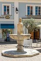
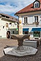
Category:Schüsselbrunnen, Feldkirchen
Jump to navigation
Jump to search
| Object location | | View all coordinates using: OpenStreetMap |
|---|
 | |||||
| Upload media | |||||
| Instance of | |||||
|---|---|---|---|---|---|
| Location | Feldkirchen in Kärnten, Feldkirchen District, Carinthia, Austria | ||||
| Street address |
| ||||
| Heritage designation | |||||
 | |||||
Media in category "Schüsselbrunnen, Feldkirchen"
The following 14 files are in this category, out of 14 total.
-
 Feldkirchen - Schüsselbrunnen.jpg 2,848 × 4,272; 3.2 MB
-
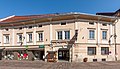
 Feldkirchen Rauterplatz 1 Bürgerhaus Hotel Germann 03092012 055.jpg 4,288 × 2,848; 1.85 MB
-
 Feldkirchen Rauterplatz 1 Bürgerhaus Hotel Germann 04062018 3566.jpg 6,141 × 3,518; 10.68 MB
-
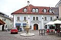 Feldkirchen Rauterplatz 2 Marktbehausung 03092012 066.jpg 4,288 × 2,848; 1.55 MB
-
 Feldkirchen Rauterplatz 3 Lebzelterbehausung 24072015 6142.jpg 4,817 × 4,532; 9.57 MB
-
 Feldkirchen Rauterplatz Schüsselbrunnen 02072016 3519.jpg 3,280 × 4,928; 6.81 MB
-
 Feldkirchen Rauterplatz Schüsselbrunnen 02072016 3520.jpg 3,280 × 4,928; 5.97 MB
-
 Feldkirchen Rauterplatz Schüsselbrunnen 02072016 3521.jpg 3,209 × 4,890; 5.73 MB
-
 Feldkirchen Rauterplatz Schüsselbrunnen 04062018 3568.jpg 4,607 × 6,308; 15.21 MB
-
 Feldkirchen Rauterplatz Schüsselbrunnen 04062018 3569.jpg 4,877 × 7,299; 19.22 MB
-
 Feldkirchen Rauterplatz Schüsselbrunnen 06062019 7118.jpg 3,280 × 4,928; 8.68 MB
-
 Feldkirchen Rauterplatz Schüsselbrunnen Jahreszahlen 10062021 1075.jpg 7,283 × 4,861; 17.49 MB
-
 Feldkirchen Rauterplatz Schüsselbrunnen SW-Ansicht 06092022 2961.jpg 4,912 × 7,360; 19.46 MB
-
 Feldkirchen Rauterplatz Schüsselbrunnen SW-Ansicht 06092022 2962.jpg 4,912 × 7,360; 14.79 MB


