Category:Satpula
Jump to navigation
Jump to search
dam in Delhi  | |||||
| Upload media | |||||
| Instance of | |||||
|---|---|---|---|---|---|
| Location | South Delhi district, Delhi division, National Capital Territory of Delhi, India | ||||
| Maintained by |
| ||||
| Heritage designation | |||||
 | |||||
This is a category about ASI monument number N-DL-86. |
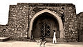
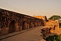
English: Satpula is a remarkable ancient water harvesting dam or weir located about 800 m (2,625 ft) east of the Khirki Masjid that is integral to the compound wall of the medieval fourth city of the Jahanpanah in Delhi, with its construction credited to the reign of Sultan Muhammad Shah Tughlaq (Muhammad bin Tughluq) (1325-1351) of the Tughlaq Dynasty.
Media in category "Satpula"
The following 22 files are in this category, out of 22 total.
-
 Passages leading into the Satpula.jpg 1,536 × 2,048; 1.47 MB
-
 Satpula (3010416926).jpg 2,048 × 1,536; 1.58 MB
-
 Satpula - stream side.jpg 2,048 × 1,536; 1.39 MB
-
 Satpula 01.JPG 4,320 × 3,240; 6.31 MB
-
 Satpula 02.JPG 4,320 × 3,240; 5.54 MB
-
 Satpula 03.JPG 4,320 × 3,240; 5.95 MB
-
 Satpula 04.JPG 4,320 × 3,240; 6.03 MB
-
 Satpula 05.JPG 4,320 × 3,240; 6.01 MB
-
 Satpula 06.jpg 3,108 × 972; 515 KB
-
 Satpula 1.jpg 3,872 × 2,232; 6.92 MB
-
 Satpula 2.jpg 2,950 × 2,592; 5.9 MB
-
 Satpula 3.jpg 3,783 × 2,592; 6.63 MB
-
 Satpula End pavilion.jpg 2,048 × 1,536; 1.51 MB
-
 Satpula from it's "lake" (3010426020).jpg 2,048 × 1,536; 1.41 MB
-
 Satpula from it's "lake".jpg 683 × 222; 56 KB
-
 Satpula monument park, Delhi 2.jpg 4,632 × 3,474; 5.26 MB
-
 Satpula monument park, Delhi.jpg 4,632 × 3,474; 3.47 MB
-
 Satpula Platform and sluice arches.jpg 2,048 × 1,536; 1.54 MB
-
 Satpula.jpg 2,048 × 1,536; 1.54 MB
-
 SatpulaRuins.JPG 4,616 × 2,970; 2.46 MB
-
 To left of Satpula-III –216.JPG 2,048 × 1,536; 624 KB
-
 To right of Satpula.JPG 2,048 × 1,536; 617 KB

.jpg)


.jpg)


