Category:Satellite pictures of the Waikato Region
Jump to navigation
Jump to search
Subcategories
This category has the following 2 subcategories, out of 2 total.
S
Media in category "Satellite pictures of the Waikato Region"
The following 23 files are in this category, out of 23 total.
-
 Auckland.arp.750pix (cropped to Hauraki Plains).jpg 324 × 329; 23 KB
-
 Auckland.arp.750pix.jpg 1,144 × 988; 147 KB
-
 BayofPlentyA2002296.jpg 616 × 864; 493 KB
-
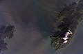 Cape Colville and Colville Channel, New Zealand, looking south (ISS016-E-12629).jpg 3,032 × 2,008; 900 KB
-
 Coromandel Harbour, New Zealand, looking southeast (ISS016-E-12626).jpg 3,032 × 2,008; 839 KB
-
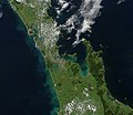
 Coromandel Peninsula and Firth of Thames, New Zealand, looking east (ISS018-E-20013).jpg 3,072 × 2,040; 734 KB
-
 Coromandel.arp.375pix.jpg 570 × 404; 38 KB
-
 Firth of Thames and Hauraki Plains, New Zealand, looking east (ISS018-E-20014).jpg 3,072 × 2,040; 734 KB
-
 Firth of Thames and Hauraki Plains, New Zealand, looking northeast (ISS018-E-20015).jpg 3,072 × 2,040; 815 KB
-
 Firth of Thames and Waihou River, New Zealand, looking southeast (ISS016-E-12624).jpg 3,032 × 2,008; 962 KB
-
 Firth of Thames, New Zealand, looking southeast (ISS016-E-12625).jpg 3,032 × 2,008; 826 KB
-
 ISS-37 Ruapehu volcano and Tongariro volcanic complex in New Zealand.jpg 4,256 × 2,832; 2.59 MB
-
 Kopuatai peat dome.jpg 552 × 501; 38 KB
-
 Lake Taupo and the Bay of Plenty, New Zealand (ISS016-E-12394).jpg 3,032 × 2,008; 965 KB
-
 Lake Taupo landsat -square crop.jpg 776 × 776; 160 KB
-
 Lake taupo landsat.jpg 1,280 × 948; 125 KB
-
 Lake Taupo, New Zealand (ISS016-E-12393).jpg 3,032 × 2,008; 941 KB
-
 Lake Taupō.jpg 5,568 × 3,712; 3.97 MB
-
 LANDSAT 2005 Slipper Island Whakahau.jpg 516 × 400; 90 KB
-
 Motuihe Island.jpg 536 × 384; 51 KB
-
 Taupo.Volcanic.Zone.North.Island.NZ.JPG 616 × 864; 104 KB
-
 Upper Coromandel Peninsula, New Zealand, looking south (ISS016-E-12628).jpg 3,032 × 2,008; 918 KB
-
 Upper Coromandel Peninsula, New Zealand, looking southeast (ISS016-E-12627).jpg 3,032 × 2,008; 899 KB
.jpg)


.jpg)
.jpg)
.jpg)

.jpg)
.jpg)
.jpg)
.jpg)


.jpg)


.jpg)


.jpg)
.jpg)