Category:Satellite pictures of ice caps
Jump to navigation
Jump to search
Media in category "Satellite pictures of ice caps"
The following 8 files are in this category, out of 8 total.
-
 Eruption of Eyjafjallajökull Volcano, Iceland 2010-04-04 lrg.jpg 4,013 × 4,013; 2.88 MB
-
Flight over the North Polar Ice Cap of Mars.webm 2 min 20 s, 1,920 × 1,080; 26.6 MB
-
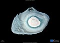
 Hoodoo Mountain satellite2.jpg 438 × 415; 21 KB
-
 Icecap melting in Russian Arctic Islands.jpg 3,508 × 2,540; 926 KB
-
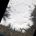
 Icecap melting in southern Greenland.jpg 3,508 × 2,540; 3.56 MB
-
 Icecap melting in the Russian High Arctic Islands.jpg 3,535 × 2,567; 2.39 MB
-
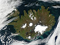 Satellite image of Iceland in September.jpeg 2,400 × 1,800; 653 KB
-
 Vatnajökull.jpeg 619 × 477; 42 KB


