Category:Santpoort-Zuid
Jump to navigation
Jump to search
| Object location | | View all coordinates using: OpenStreetMap |
|---|
village in the Netherlands   | |||||
| Upload media | |||||
| Instance of | |||||
|---|---|---|---|---|---|
| Part of | |||||
| Location | Velsen, North Holland, Netherlands | ||||
| official website | |||||
 | |||||
Subcategories
This category has the following 7 subcategories, out of 7 total.
B
P
R
S
- Santpoort Zuid railway station (23 F)
- Stolpersteine in Santpoort-Zuid (20 F)
- SV Terrasvogels (1 F)
Media in category "Santpoort-Zuid"
The following 18 files are in this category, out of 18 total.
-

-

-

-
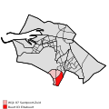 Map - NL - Velsen - Wijk 07 Santpoort-Zuid - Buurt 03 Eltabuurt.svg 375 × 375; 40 KB
-
 Map - NL - Velsen - Wijk 07 Santpoort-Zuid.svg 625 × 575; 15 KB
-
 Map NL - Velsen - Santpoort-Zuid.svg 800 × 600; 26 KB
-
 Alberdingk Thijmlaan, NL-HlmNHA 54012705.JPG 2,117 × 1,431; 510 KB
-
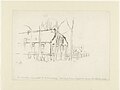 De boerderij Sinneveld ad Rijksstraatweg door A, Inventarisnummer NL-HlmNHA 53004893.JPG 5,182 × 3,908; 2.8 MB
-
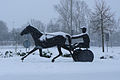
 De Draver van Yvonne Piller. Informatiebord.jpg 4,000 × 3,000; 4.53 MB
-
 De Draver van Yvonne Piller.jpg 4,000 × 3,000; 3 MB
-

-
 Gegevens cataloguskaartje Santpoort, Inventarisnummer NL-HlmNHA 1100 KNA006002245.JPG 2,493 × 2,014; 2.04 MB
-

-
 Harddraver.jpg 700 × 467; 119 KB
-

-
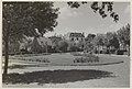
 Restaurant Châlet de Uilenboom aan de Wüstelaan 75. NL-HlmNHA 54020848.JPG 2,159 × 1,549; 643 KB
-

-
 Teekening van Sinneveld door A, Inventarisnummer NL-HlmNHA 53004894.JPG 5,208 × 3,832; 3.23 MB


