Category:Sankt Sørens Kirke
Jump to navigation
Jump to search
| Object location | | View all coordinates using: OpenStreetMap |
|---|
church building in Skanderborg Municipality, Denmark  | |||||
| Upload media | |||||
| Instance of | |||||
|---|---|---|---|---|---|
| Location | Old Rye, Skanderborg Municipality, Central Denmark Region, Denmark | ||||
| Street address |
| ||||
| Diocese | |||||
| Religion or worldview | |||||
| official website | |||||
 | |||||
Media in category "Sankt Sørens Kirke"
The following 17 files are in this category, out of 17 total.
-
 09-06-22-q3-Gammel Rye, Skt. Sørens kirke (Skanderborg).JPG 1,234 × 964; 636 KB
-
 Biskop Svend32.jpg 526 × 1,000; 408 KB
-
 Gl. Rye - panoramio (1).jpg 3,072 × 2,304; 1.61 MB
-
 Påskeliljer ved Gammel Ry.jpg 3,872 × 2,592; 2.67 MB
-
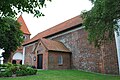
 Sankt Sørens Kirke from the north east.jpg 4,016 × 2,674; 8.45 MB
-
 Sankt Sørens Kirke from the south east.jpg 4,016 × 2,674; 10.9 MB
-
 Sankt Sørens Kirke, alteret.JPG 1,880 × 2,816; 1.65 MB
-
 Sankt Sørens Kirke, døbefonten.JPG 1,616 × 2,424; 1.61 MB
-
 Sankt Sørens Kirke, epitafiet.JPG 1,576 × 2,364; 1.24 MB
-
 Sankt Sørens Kirke, kirkeskibet.JPG 2,816 × 1,880; 1.63 MB
-
 Sankt Sørens Kirke, koret.JPG 2,602 × 1,735; 1.6 MB
-
 Sankt Sørens Kirke, krucifikset.JPG 1,648 × 2,511; 1.17 MB
-
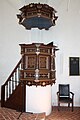 Sankt Sørens Kirke, prædikestolen..JPG 1,764 × 2,646; 1.52 MB
-
 Sankt Sørens Kirke.1.jpg 3,872 × 2,592; 2.36 MB
-
 Sankt Sørens kirke.jpg 858 × 630; 653 KB
-
 Sankt Sørens Kirkes indre set mod vest.JPG 2,816 × 1,880; 1.7 MB
-
 The tower at Sankt Sørens Church.jpg 2,674 × 4,016; 9.55 MB
.JPG)

.jpg)


