Category:Sankey Viaduct
Jump to navigation
Jump to search
| Object location | | View all coordinates using: OpenStreetMap |
|---|
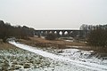
grade I listed railway viaduct in Cheshire and Merseyside, UK  | |||||
| Upload media | |||||
| Instance of | |||||
|---|---|---|---|---|---|
| Location |
| ||||
| Bridge number |
| ||||
| Architect | |||||
| Crosses |
| ||||
| Carries | |||||
| Heritage designation |
| ||||
| Inception |
| ||||
| Width |
| ||||
 | |||||
Numbered DSE/89 by Network Rail and is 14.1 miles from the datum at Liverpool Lime Street. Numbered 23 on the Sankey Canal by CART.
Subcategories
This category has only the following subcategory.
S
Media in category "Sankey Viaduct"
The following 28 files are in this category, out of 28 total.
-

-
 2004-10-09 Nine Arches.jpg 1,728 × 2,304; 802 KB
-
 2004-10-09 Sankey Brook.jpg 1,728 × 2,304; 785 KB
-
 2004-10-09 Viaduct from valley.jpg 1,728 × 2,304; 1.31 MB
-
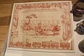 Cloth print engraving of the Sankey Viaduct crossing the Sankey Canal, 1830-2.jpg 4,272 × 2,848; 5.54 MB
-
 Cloth print engraving of the Sankey Viaduct crossing the Sankey Canal, 1830.jpg 4,272 × 2,848; 6.6 MB
-
 Newton-le-Willows banner Sankey Viaduct.jpg 4,021 × 574; 969 KB
-

-
 Sankey Railway Viaduct, Newton le Willows - geograph.org.uk - 3743511.jpg 1,024 × 768; 164 KB
-
 Sankey Viaduct (Percival Skelton).jpg 536 × 483; 145 KB
-
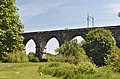
 Sankey Viaduct - geograph.org.uk - 217761.jpg 640 × 448; 39 KB
-
 Sankey Viaduct - geograph.org.uk - 2583405.jpg 1,600 × 1,067; 382 KB
-
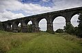
 Sankey Viaduct - geograph.org.uk - 30807.jpg 640 × 426; 104 KB
-
 Sankey Viaduct - geograph.org.uk - 6300864.jpg 3,264 × 2,448; 2.86 MB
-
 Sankey Viaduct - October 2016.jpg 4,032 × 2,268; 4.73 MB
-
 Sankey Viaduct 1.jpg 4,504 × 2,430; 14.89 MB
-
 Sankey Viaduct 2.jpg 4,575 × 3,280; 22.35 MB
-
 Sankey Viaduct 3.jpg 4,558 × 2,714; 18.06 MB
-
 Sankey Viaduct 4.jpg 4,471 × 2,848; 18.55 MB
-
 Sankey Viaduct 5.jpg 5,045 × 3,322; 21.66 MB
-
 Sankey Viaduct 6.jpg 5,091 × 3,391; 23.34 MB
-
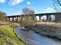
 Sankey Viaduct crosses Sankey Valley Park - geograph.org.uk - 1976056.jpg 1,600 × 1,198; 461 KB
-
 Sankey Viaduct-geograph-3319677.jpg 640 × 480; 386 KB
-
 Sankey viaduct.jpg 3,441 × 2,236; 1.89 MB
-
 Stephenson's Sankey Viaduct at Earlestown - geograph.org.uk - 78705.jpg 640 × 427; 138 KB
-
-
 Train on the Sankey Viaduct - geograph.org.uk - 2745750.jpg 4,000 × 3,000; 1.45 MB
-
 Underneath Sankey Viaduct - geograph.org.uk - 1976067.jpg 1,600 × 1,198; 647 KB


.jpg)


Categories:
- Burtonwood and Westbrook
- Earlestown
- Sankey Valley Park, St Helens
- Liverpool and Manchester Railway
- Railway bridges in the Metropolitan Borough of St Helens
- Railway viaducts in Cheshire
- Railway viaducts in Merseyside
- Grade I listed buildings in Merseyside
- Grade I listed bridges in Cheshire
- Listed buildings in Earlestown
- Bridges numbered 23
- Bridges numbered 89